
Server Costs Fundraiser 2026


A map indicating the battle lines at the Battle of Crécy in northern France on 26 August 1346 CE between England and France. The English, led by Edward III of England (r. 1327-1377 CE), were victorious in the first major battle of the Hundred Years’ War (1337-1453 CE).
Related Images

Map of Jeanne d’Arc's Campaigns and The Hundred Years' War - Dynastic conflict, civil war & French resurgence, 1429–53
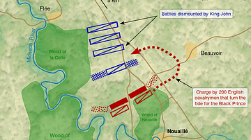
Battle of Poitiers Map
Map of New England
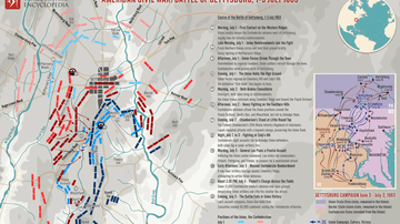
Map of Battle of Gettysburg during the American Civil War

Map of the Western Front in World War I, 1914-1918

Map of a Circumnavigation of the Black Sea c. 130 CE - Arrian of Nicomedia's "Periplus Ponti Euxini"
Cite This Work
APA Style
westpoint.edu. (2020, February 25). Battle of Crécy Map. World History Encyclopedia. https://www.worldhistory.org/image/11939/battle-of-crecy-map/
Chicago Style
westpoint.edu. "Battle of Crécy Map." World History Encyclopedia, February 25, 2020. https://www.worldhistory.org/image/11939/battle-of-crecy-map/.
MLA Style
westpoint.edu. "Battle of Crécy Map." World History Encyclopedia, 25 Feb 2020, https://www.worldhistory.org/image/11939/battle-of-crecy-map/.