


A map of West Africa from the 1375 CE Catalan Atlas. The map shows the trans-Saharan caravan trade routes between North Africa and the Niger River. (Sheet 6, National Library of France, Paris)
Related Images

Map of the Mali Empire under Mansa Musa, c.1337 - Power, Gold, and the Trans-Saharan Trade Network

Mansa Musa of the Mali Empire
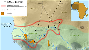
Map of the Mali Empire, c. 1337 CE

Cavalry Warrior, Mali Empire

Great Mosque, Djenne, Mali

Tellem or Dogon Headrest from Mali
Cite This Work
APA Style
Library, G. D. (2019, March 11). Western Sahara, Catalan Atlas. World History Encyclopedia. https://www.worldhistory.org/image/10166/western-sahara-catalan-atlas/
Chicago Style
Library, Gallica Digital. "Western Sahara, Catalan Atlas." World History Encyclopedia, March 11, 2019. https://www.worldhistory.org/image/10166/western-sahara-catalan-atlas/.
MLA Style
Library, Gallica Digital. "Western Sahara, Catalan Atlas." World History Encyclopedia, 11 Mar 2019, https://www.worldhistory.org/image/10166/western-sahara-catalan-atlas/.