
Search
Remove Ads
Advertisement
Search Results
Image
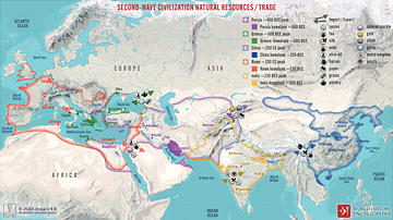
Second-Wave Civilization Natural Resources and Trade
A map illustrating the rise and spread of the Second Wave Civilizations between c. 500 BCE and 200 CE (including the Persians, the Greeks, the Romans, the Chinese, and India) with the flows of trade in major goods and resources.

Image
Slave Trade
Execrable Human Traffick, or The Affectionate Slaves, oil on canvas by George Morland, c. 1788. Depicted here is a scene of a man being abducted by slavers on the coast of Africa as his family watches. From the 16th to the 19th century...

Definition
Djenne-Djenno
Djenne-Djenno (aka Djenné-Jeno, Jenne-Jeno, or Old Jenne) was an ancient city located in modern Mali, West Africa which flourished between c. 250 BCE - 1100 CE, making it one of the oldest cities in Sub-Saharan Africa. Prospering thanks to...

Article
Interrelations of Kerma and Pharaonic Egypt
The vacillating nature of Ancient Egypt's associations with the Kingdom of Kerma may be described as one of expansion and contraction; a virtual tug-of-war between rival cultures. Structural changes in Egypt's administration led to alternating...

Article
Cultural Links between India & the Greco-Roman World
Cyrus the Great (558-530 BCE) built the first universal empire, stretching from Greece to the Indus River. This was the famous Achaemenid Empire of Persia. An inscription at Naqsh-i-Rustam, the tomb of his able successor Darius I (521-486...

Image
Map of the Trade Networks in the Middle Ages, c. 1200
By the early 13th century (c. 1200 CE), long-distance trade networks across Eurasia and the Mediterranean had regained a level of interconnectivity not seen since late antiquity. After the political fragmentation that followed the fall of...

Image
Map of the Roman Trade with the East, c. 1st–3rd Centuries - Silk Roads and Indian Ocean Routes across Afro-Eurasia
Roman trade with the East refers to the overland and maritime exchange networks that connected the Roman Empire with Parthian Iran, the Kushan Empire, India, Southeast Asia, Han China, and, from the 3rd century CE, the Sasanian Empire. During...
Image
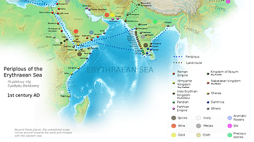
Ancient Indian Maritime Trade Routes
This map is derived from the book Periplus of the Erythraean Sea. It depicts trade routes in the ancient world, ports in the Chera territory and other parts of India and the trade routes connecting them to other parts of the world along with...

Definition
East India Company
The English East India Company (EIC or EEIC), later to become the British East India Company, was founded in 1600 as a trading company. With a massive private army and the backing of the British government, the EIC looted the Indian subcontinent...

Definition
Dutch East India Company
The Dutch East India Company (VOC) was formed in 1602 by the Staten-Generaal (States General) of the then Republic of the Seven United Netherlands. The company was granted a 21-year charter with rights to trade exclusively in Asia and to...