
Search
Remove Ads
Advertisement
Search Results

Article
Korean Celadon Pottery
The celadon (or greenware) ceramics produced in ancient Korea during the Goryeo Dynasty (918-1392 CE), are regarded as some of the finest and most elegant pottery pieces produced anywhere. With a pale green lustre reminiscent of jade and...
Image
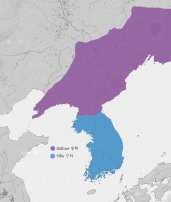
Unified Silla & Balhae Kingdoms
A map showing the territory of the Unified Silla Kingdom (668- 935 CE) and Balhae (Parhae) Kingdom (698-926 CE), which controlled parts of Manchuria.
Article
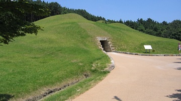
The Tomb of King Muryeong
The tomb of king Muryeong is perhaps one of the most impressive tombs from the Baekje kingdom of ancient Korea, both in its design and the treasure found inside it. Muryeong-Wang (also Munyeong or Muryong) reigned from 501 to 523 CE. Baekje...

Definition
Taejo of Goryeo
Taejo (r. 918-943 CE), previously known as Wang Geon or Wang Kon, was the founder and first king of the Goryeo (Koryo) kingdom which unified and ruled ancient Korea from 918 CE to 1392 CE. Wang Geon was given the posthumous title of Taejo...

Image
Muryangsujeon, Buseoksa, Korea
The Muryangsujeon (Murangsu-jŏn) hall, part of the Buseoksa temple complex, Gyeongsangbuk-do Province, South Korea. Buddhist temples were first constructed at the site in the 7th century CE but the hall dates to the Goryeo (Koryo) period...
Definition
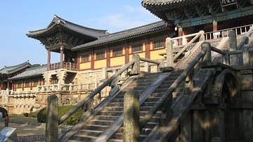
Bulguksa Temple
The Bulguksa Temple (aka Pulguk-sa Temple or 'Temple of the Buddha Land') was built in the 8th century CE on the wooded slopes of Mt. Tohamsan at the ancient Silla capital of Geumseong (modern Gyeongju, South Korea). The Buddhist temple...
Definition
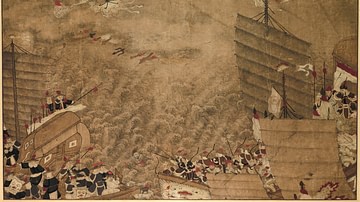
Wako - The Medieval Pirates of Southeast Asia
Wako (aka wokou and waegu) is a term used to refer to Japanese (but also including Chinese, Korean, and Portuguese) pirates who plagued the seas of East Asia from Korea to Indonesia, especially between the 13th and 17th centuries CE. Besides...

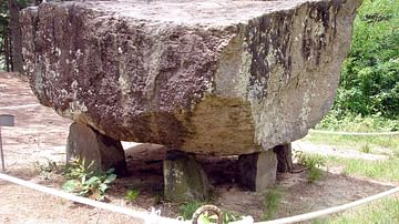
Image
Table Dolmen, Ganghwa, Korea
A Bronze Age table dolmen on the island of Ganghwa, South Korea. c. 1000 BCE. Such structures were built above tombs of the elite.

Image
Dolmen, Gochang, Korea
A Neolithic/Bronze Age dolmen at Gochang, Korea.
Image
Dolmen, Gochang Korea
A Neolithic/Bronze Age dolmen at Gochang, Korea.