
Search
Remove Ads
Advertisement
Search Results

Image
Map of Spanish Main & West Indies c.1720 - Treasure Fleets and Imperial Competition in the 18th Century
During the 18th century, the Caribbean Sea and the Gulf of Mexico formed one of the most strategically contested regions of the Atlantic world. Initially dominated by the Spanish Empire, this maritime zone, often referred to as the Spanish...

Image
Map of the Spanish Empire and the Indies (c. 1500-1820)
The emergence of Spain as a global imperial power began with the dynastic union of the crowns of Castile and Aragon under Isabella I of Castile (reign 1474–1504) and Ferdinand II of Aragon (reign 1479–1516). Their reigns marked a turning...

Image
Map of the Spanish Main & Caribbean Pirate Havens c. 1670 - Trade, Treasure, and the Golden Age of Piracy
This map illustrates the maritime routes of Spain’s Treasure Fleets and the network of Caribbean ports and pirate havens around 1670. It captures the tension between imperial commerce and maritime raiding, showing both the logistical arteries...

Image
La Malinche Leads the Spanish
La Malinche leading Hernán Cortés and the Spanish, illustration in Codex Azcatitlan by unknown author, p. 23, c. 1501-1600. This image is an indigenous pictorial representation of the Spanish marching on the Aztec capital with La Malinche...

Definition
Galleon
The galleon (Spanish: galeón, French: galion) was a type of sailing ship used for both cargo carrying and as a warship. Galleons dominated the seas in the second half of the 16th century, and with their lower superstructures, they were much...

Image
Map of Spanish Conquest & Exploration in North America
This map illustrates the expansion of Spanish imperial power following the completion of the Reconquista in 1492 and the voyages of Christopher Columbus (first voyage 1492). Fueled by promises of land, gold, and glory, Spain launched one...

Image
Map of the Spanish Conquest & Exploration in South America
Spain’s rapid expansion into South America followed the consolidation of its Caribbean footholds by 1512, marking a decisive shift from exploration to imperial conquest. Under the reign of Ferdinand II of Aragon (reign1479–1516) and later...

Article
The Silver of the Conquistadors
The Spanish conquistadors might have gained a lasting reputation as the great gold-seekers of history, but they were actually far more successful in acquiring silver. Over 100 tons of gold were extracted from the Americas from 1492 to 1560...

Article
La Malinche - A Complicated Woman in Context
La Malinche, or Malintzin, was the primary interpreter in the retinue of Hernán Cortés during his conquest of Mexico in the early 16th century and has become one of the most divisive women in Mexican history. Though she was called Malintzin...
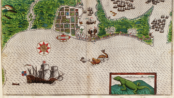
Image
Cartagena on the Spanish Main
A c. 1589 map showing the port of Cartagena on the Spanish Main (now in modern Colombia). Cartagena was one of the main ports for the Spanish treasure fleets and acted as a collecting point for gold, silver, emeralds, and pearls from Colombia...