
Search
Remove Ads
Advertisement
Search Results
Image
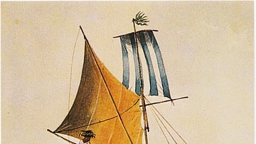
Painting of Tahitian Polynesians in a Canoe
This painting is of Tahitians in a canoe and was done by Henry Byam Martin, a ship captain who visited Tahiti in the mid-1800s CE. Martin was a captain in the British Navy who painted and drew during his...

Video
Rapa Nui National Park (UNESCO/NHK)
Rapa Nui, the indigenous name of Easter Island, bears witness to a unique cultural phenomenon. A society of Polynesian origin that settled there c. A.D. 300 established a powerful, imaginative and original tradition...

Image
Map of the Portuguese Commercial Empire, c. 1580 - Fortified Ports, Maritime Trade Routes, and Global Sea Power
Portugal established the first and longest-lasting of Europe’s overseas empires, developing a maritime-commercial network that connected the Atlantic...

Image
Map of European Exploration of Africa, c. 1434-1877 - From Coastal Voyages to Continental Expeditions
From the voyages of the Portuguese navigators under the patronage of Henry the Navigator in the 15th century to the transcontinental expeditions of Henry Morton...

Image
The Twelve Longest Discovery Expeditions in the Age of Sail - Exploration, Science, and the Expansion of Global Knowledge
The Age of Sail (c. 1400–1860) produced some of history’s longest exploratory and scientific expeditions, driven by trade, imperial rivalry, navigation...

Image
Map of Arctic Discovery and Exploration
Arctic exploration represents one of humanity’s most formidable quests for discovery, driven by scientific curiosity, commercial ambition, and geopolitical competition. From the early voyages of Henry Hudson...

Image
Map of the Scientific Voyages of Edmond Halley (c.1676–1721)
The travels of Edmond Halley (1656–1742) exemplify the expanding reach of scientific inquiry during the late 17th and early 18th centuries, an era shaped by the Scientific Revolution. Operating...

Image
Magnetic Sea Chart by Halley
A detail of a chart showing lines of magnetic compass variation made in 1702 by the English scientist and cartographer Edmond Halley (1656-1742). Halley hoped the chart would aid navigation but the variations in magnetism...

Image
View of the Hudson River Valley from West Point
West Point and the Highlands, colour engraving by Samuel Valentine Hunt, 1869. Depicted here is a view from the heights of the west bank of the Hudson River, looking northward along the valley. The United...

Video
Rock Drawings in Valcamonica (UNESCO/NHK)
Valcamonica, situated in the Lombardy plain of Italy, has one of the world's greatest collections of prehistoric petroglyphs — more than 140,000 symbols and figures carved in the rock over a period of 8,000...
