
Search
Remove Ads
Advertisement
Search Results

Image
Death of Pakenham at New Orleans
Death of British Maj. Gen. Sir Edward Pakenham (1778-1815) at the Battle of New Orleans (8 Jan 1815). Artwork by F. O. C. Darley, engraved by W. Ridgway, 1860.
Library of Congress, Washington, D.C.

Image
Battle of New Orleans
A 1910 print by Edward Percy Moran of the Battle of New Orleans. On 8 January 1815, the U.S forces, commanded by General Andrew Jackson, successfully defended the city against an attack by a British force. (Library of Congress)

Image
Te Waimate Mission, New Zealand
Three houses of similar design were originally constructed at the Te Waimate Mission in the Bay of Islands, New Zealand. This is the only house still standing on the site and it was built in 1832 CE. The photo is a close-up view of the low-pitched...

Image
New Testament
Altar in the Collegiate church, Monastery Endowment of the Holy Grave, Heiligengrabe, Brandenburg, Germany.
Image
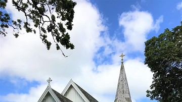
St. John's Church, Waimate North, New Zealand
St. John’s Church is a part of the Te Waimate mission and is a stunning example of Gothic Revival architecture. It was built in 1871 as a replacement for the 1839 chapel.
Image
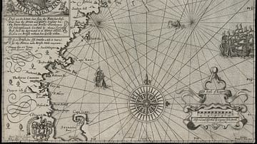
Map of New England
Map of New England by Captain John Smith
Printed by Geor. Low, 1624 CE
Based on Smith's 1614 CE voyage, this is the first printed map to use the name “New England” for the region and was used by the pilgrims who founded Plymouth Colony.
Image
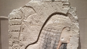
New Kingdom Nobleman
A limestone relief depicting a nobleman, New Kingdom, Dynasty XIX or XX, c. 1295-1070 BCE. The figure is probably a scene from an offering in the Underworld. On the left side a hand is holding a sistrum and flower. (Brooklyn Museum, New York...

Image
First Page of the Gospel of John from Tyndale's New Testament
The first page of the Gospel of John from the New Testament of William Tyndale (c. 1494-1536), published in 1526, the first English translation of the New Testament from the original languages.
Image
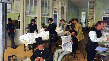
The Cotton Market, New Orleans by Degas
An 1873 oil on canvas painting, The Cotton Market, New Orleans (aka The Cotton Office), by Edgar Degas (1834-1917), the French impressionist painter. The scene shows a busy office with 13 people, including buyers, brokers, and office layabouts...

Image
Plants Found in New Holland.
Illustration of Australian plants found in New Holland (Australia) by William Dampier (1651-1715) - from Dampier's book A Voyage to New Holland (1703).