
Search
Did you mean: Midas?
Remove Ads
Advertisement
Search Results
Definition
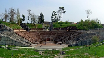
Augusta Raurica
Augusta Raurica is a former Roman colony and city located on the Rhine River some 11 km (7 miles) east of the modern Swiss city of Basel, in between the towns of Kaiseraugst and Augst. Founded by Lucius Munatius Plancus (90 BCE - 15 BCE...
Image
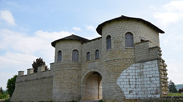
Reconstructed Gate of the Roman Fort Biriciana, Germany
The reconstructed gate of the Roman fort Biriciana in Weißenburg (Germany) along the Limes Germanicus. Biriciana was the garrison of the Ala I Hispanorum Auriana between the last years of the 1st century CE and the end of the Limes in the...

Image
Map of the Travels of Hadrian & the Roman Empire c. 125 CE
This map illustrates the Roman Empire under Emperor Hadrian (r. 117–138 CE), who succeeded Trajan (r. 98–117 CE) at the height of Rome’s territorial expansion. Unlike his predecessor, Hadrian chose consolidation over conquest, shaping the...

Article
7 Ancient Sites in Georgia
Georgia, lying at the junction of Europe and Asia, is a country of ancient myths with a rich and turbulent history. Home to the first European hominids and the birthplace of wine, Georgia's roots trace back to ancient civilisations. Throughout...
Article
Hadrian's Travels
No other Roman emperor travelled as much as Hadrian (r. 117-138 CE). The 'restless' emperor spent more time travelling than in Rome, devoting half of his 21-year reign to the inspection of the provinces. His travels provided him with the...

Article
Top 10 Sights along Hadrian's Wall
The 1,900th anniversary of the visit of the Roman emperor Hadrian (r. 117-138 CE) to Britain and the construction of the wall that bears his name will be observed in 2022. A year-long festival will be held, filled with hundreds of events...

Video
Frontiers of the Roman Empire (UNESCO/NHK)
The 'Roman Limes' represents the border line of the Roman Empire at its greatest extent in the 2nd century AD. It stretched over 5,000 km from the Atlantic coast of northern Britain, through Europe to the Black Sea, and from there to the...

Image
Map of Roman Gaul from Conquest to Integration, c. 200 CE - Provincial Order and Frontier Power in the Roman West
The Roman incorporation of Gaul began with the campaigns of Julius Caesar (58–51 BCE) and resulted in the gradual transformation of a diverse Celtic region into an integral part of the Roman world. By c. 200 CE, Gaul was organized into a...
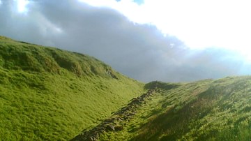
Definition
Antonine Wall
The Antonine Wall was the north-west frontier of the Roman Empire. Located in central Scotland, north of Edinburgh and Glasgow, the Wall was a linear barrier that stretched from the Firth of Forth near Bo'ness to the Clyde estuary at Old...

Image
Saalburg Roman Fort, Germany
The Saalburg is a reconstructed Roman cohort fort located northwest of Bad Homburg in Hesse (Germany) and belonging to the Limes Germanicus. This fort served for 150 years as a base for frontier troops stationed along the Roman Frontier in...