
Search
Remove Ads
Advertisement
Search Results

Definition
Karnak
Karnak is the modern-day name for the ancient site of the Temple of Amun at Thebes, Egypt. The Egyptians called the site Nesut-Towi, "Throne of the Two Lands", Ipet-Iset, "The Finest of Seats" as well as Ipt-Swt, "Selected Spot" also given...

Image
Map of the Bosporan Kingdom, c.100 CE - Gateway Between Steppe, Caucasus, and Rome
The Bosporan Kingdom (c. 480 BCE–341 CE) emerged around the Cimmerian Bosporus (modern Kerch Strait) as a hybrid Greco-local state founded by Greek colonists from cities such as Miletus. Rather than a single unified polity in the modern sense...
Article
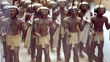
Weapons in Ancient Egypt
The ancient Egyptian military is often imagined in modern films and other media as a heavily armed and disciplined fighting force equipped with powerful weapons. This depiction, however, is only true of the Egyptian army of the New Kingdom...

Article
Interrelations of Kerma and Pharaonic Egypt
The vacillating nature of Ancient Egypt's associations with the Kingdom of Kerma may be described as one of expansion and contraction; a virtual tug-of-war between rival cultures. Structural changes in Egypt's administration led to alternating...

Image
Map of the Ptolemaic Kingdom of Egypt c. 240 BCE - Power, Wealth, and Rivalry in the Hellenistic World
By c. 240 BCE, Ptolemaic Egypt stood as one of the most powerful and stable successor states of Alexander’s empire, reaching a high point under Ptolemy III Euergetes (reign 246-222 BCE). Emerging from the fragmentation that followed the death...

Definition
The Hittites
The Hittites occupied the ancient region of Anatolia (also known as Asia Minor, modern-day Turkey) prior to 1700 BCE, developed a culture apparently from the indigenous Hatti (and possibly the Hurrian) people, and expanded their territories...
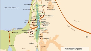
Image
Map of the Nabatean Kingdom
Map of the Nabatean Kingdom at its greatest extent, c. 85 BCE.

Image
Map of Kingdom of Axum
A map indicating the area controlled by the African kingdom of Axum (1st-8th century CE) on the coast of the Red Sea.

Image
Map of the Macedonian Kingdom at Philip II's Death c.336 BCE - Legacy and the Road to Imperial Expansion
At the time of Philip II’s death (reign 359–336 BCE), the Kingdom of Macedon had emerged as the dominant power in the Hellenic world. Through sustained military reform, most notably the development of the Macedonian phalanx, and a combination...

Image
Map of the Zulu Kingdom and British Imperial Expansion - The Anglo-Zulu War - Conquest & the Struggle for Power
The Zulu Kingdom emerged in the early 19th century as a centralized and militarized state under Shaka Zulu (reign c. 1816–1828), whose reforms reshaped regional power dynamics in southeastern Africa. By the later 19th century, the kingdom...