
Search
Did you mean: Writing?
Remove Ads
Advertisement
Search Results
Image
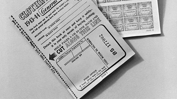
British Clothing Ration Book
A clothing ration book used during rationing in wartime Britain. (Imperial War Museums)
Image
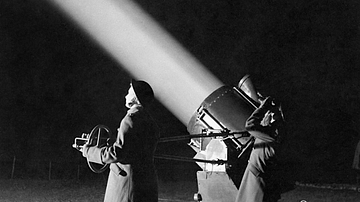
British Searchlight Operators
Auxiliary Territorial Service (ATS) personnel operating a searchlight during the Second World War (1939-45). Searchlights, often with the aid of radar, could help identify enemy aircraft for anti-aircraft gunners to shoot.

Image Gallery
5 British Royal Houses
In this gallery, we look at the history of the last five royal houses of Britain through their family trees. From the Wars of the Roses to the current House of Windsor, we see an evolution from absolute rule to a constitutional monarchy...

Image Gallery
8 Maps on British History
In this gallery of eight maps, we examine the history of Britain by looking at the four great challenges faced from the outside: Rome, Scandinavia, Normandy, and Spain, as well as that which came from within and the chaotic civil war of the...

Image
Map of the British Raj c. 1930
A map illustrating the British Raj around 1930, a period of direct British rule over the Indian subcontinent that began in 1858. Following the Sepoy Mutiny of 1857, also known as the First War of Independence, the British Parliament passed...

Definition
First Anglo-Afghan War
The First Anglo-Afghan War (1838-42) was fought between the British East India Company (EIC) and, the Emirate of Afghanistan, the ultimate victor. The British were keen to control Afghanistan as they feared Russian expansion into South Asia...

Definition
Anglo-Zulu War - Britain's Invasion of Zululand
The Anglo-Zulu War of 1879 saw British-led armies invade the Zulu Kingdom in Southern Africa as part of a wider plan to unify various territories into a single British-controlled state. Despite their spectacular success in the opening Battle...

Image
Map of the British Conquest in India c. 1857
This map illustrates the rapid and often chaotic expansion of British control in India between the Battle of Plassey in 1757 and the eve of the Indian Rebellion in 1857. During this century, the East India Company transformed from a trading...

Image
Map of the Zulu Kingdom and British Imperial Expansion - The Anglo-Zulu War - Conquest & the Struggle for Power
The Zulu Kingdom emerged in the early 19th century as a centralized and militarized state under Shaka Zulu (reign c. 1816–1828), whose reforms reshaped regional power dynamics in southeastern Africa. By the later 19th century, the kingdom...
Image
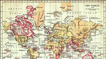
Map of the British Empire, 1897
An 1897 map showing the territories of the British Empire (shown in red). (Cambridge University Library)