
Search
Did you mean: Anu?
Remove Ads
Advertisement
Search Results
Definition
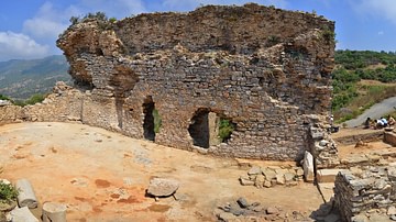
Antiochia ad Cragum
Antiochia ad Cragum (“Antioch on the Cliffs” or “Antioch at Cragus”) was a Hellenistic Roman city located in Cilicia Trachea (“Rough Cilicia”, also known as Cilicia Aspera and Cilicia Secunda) on the southern coast of modern-day Turkey (in...
Article
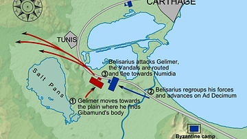
Battle of Ad Decimum
The Battle of Ad Decimum near Carthage, North Africa took place in September 533 CE and was the first major battle of the Vandalic War (533 - 534 CE) between the forces of the Byzantine Empire and the Vandal Kingdom. Leading the Vandals was...
Image
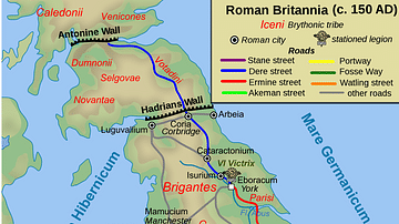
Map of Roman Britain, 150 AD
Map of Roman Britain ca. 150 AD, showing the main Roman roads, cities, and Brythonic tribes.

Image
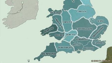
Map of the British Isles in AD 43
On the eve of the Roman Conquest, the south-east was dominated completely by the Catuvellauni. They, if any, could claim the legendary High Kingship of Britain. As well as having conquered the Cantiaci, the Trinovantes, and the Atrebates...

Image
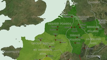
Map of the Frankish Kingdoms AD 511
The founder of the Merovingian Frankish kingdom was Clovis. He followed an aggressive policy of conquest to build up the kingdom over much of modern France, but his death in 511 saw his realm chopped up into several smaller kingdoms. It...
Image
Map of the Frankish Kingdoms AD 481-511
With the accession of Clovis, son of Childeric I of the Salian Franks, the Germanic occupiers of north-eastern Gaul had found a king who would change their fortunes out of all recognition. Rather than follow his father's policy of allying...
Image
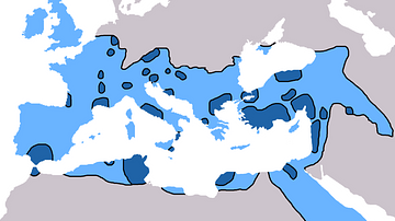
Spread of Christianity 325-600 AD
This map shows the spread of Christianity around the Mediterranean and Europe. Dark Blue: Spread until 325 AD. Light Blue: Spread until 600 AD. Patrick O'Brien, ed (2003). Atlas of World History. New York: Oxford University Press...

Image
Damnatio ad Bestias Mosaic
Roman mosaic depicting damnatio ad bestias where two condemned men are being thrown to the beasts. The arena is littered with spears and splashes of blood. Numerous animals can be seen, including five bears and six big cats. In the two surviving...
Image
Map of the British Isles in AD 10
Rome maintained trading and political links of a sort with the Britons, and were able to observe the slow coalescence of the south-east towards the creation of a unified kingdom. The Catuvellauni, who had already proved themselves to be...
Image
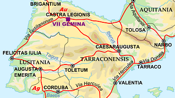
Map of the Iberian Penninsula in 125 AD
A map showing Iberian peninsula in 125 AD including important roads, locations of legions and gold (Au) and silver (Ag) mines.