
Search
Did you mean: Tiglath Pileser I?
Remove Ads
Advertisement
Search Results

Image
Assyrian Deportation of People
Assyrian relief, from the Central Palace at Nimrud (ancient Kalhu), Mesopotamia, Iraq. This is one of a series of panels that showed Tiglath-Pileser III's military campaigns in modern-day southern Iraq. On the left is a captured town, with...
Image
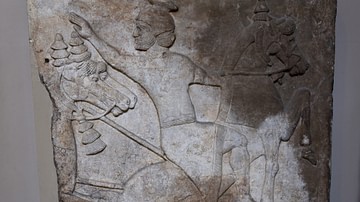
Surrender of Horseman, Assyrian Relief
Assyrian relief, from the Central Palace at Nimrud (ancient Kalhu), Mesopotamia, modern-day Iraq, reused later in the South-West Palace, from the reign of Tiglath-Pileser III, c. 728 BCE. This scene, with a fleeing enemy horseman turning...
Image
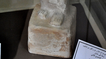
Statue of Yerah' Azar
The inscriptions of this limestone statue mention that the statue belongs to Yerah'Azar, son of Zakir, son of Sanipu. Sanipu is known to have submitted to the Assyrian king Tiglath-Pileser III in the year 733 BCE. The eyes were originally...

Definition
Dur-Sharrukin
Dur-Sharrukin (modern Khorsabad, Iraq) was a city built by Sargon II of Assyria (r. 722-705 BCE) as his new capital between 717-706 BCE. The name means Fortress of Sargon and the building project became the king's near obsession as soon as...

Definition
Tushpa
Tushpa, later known as Van, was the capital of the Urartu kingdom of ancient Armenia, eastern Turkey, and western Iran from the 9th to 6th century BCE. Located on the eastern shore of Lake Van in modern Turkey, the city was a fortress site...

Image
Map of the Middle Assyrian Empire
The Middle Assyrian Empire emerged amid the dynamic political realignments of the Ancient Near East during the Late Bronze Age, as Assyria reasserted its independence and rose from a regional kingdom into a formidable imperial power. Following...

Image
Neo-Assyrian Empire
Map of the Neo-Assyrian Empire and its expansions.
Image
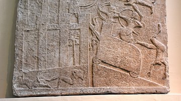
Babylonian City under Assyrian Siege
Assyrian relief showing a siege, from the Central Palace at Nimrud (ancient Kalhu), Mesopotamia, Iraq. Date palms indicate that the city, most of which was on an adjacent slab, was probably Babylonia. The Assyrians have built a siege ramp...

Definition
Fertile Crescent - A Modern Term For An Ancient Region
The Fertile Crescent, often called the 'cradle of civilization', is the region in the Middle East that curves like a quarter-moon shape from the Persian Gulf through modern-day southern Iraq, Syria, Lebanon, Jordan, Israel, and northern Egypt...

Definition
Nineveh - The Great Cultural Center That Became the "City of Sin"
Nineveh (modern-day Mosul, Iraq) was one of the oldest and greatest cities in antiquity. It was originally known as Ninua, a trade center, and would become one of the largest and most affluent cities in antiquity. It was regarded highly by...