
Search
Remove Ads
Advertisement
Search Results
Image
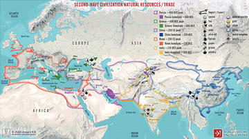
Second-Wave Civilization Natural Resources and Trade
A map illustrating the rise and spread of the Second Wave Civilizations between c. 500 BCE and 200 CE (including the Persians, the Greeks, the Romans, the Chinese, and India) with the flows of trade in major goods and resources.
Image
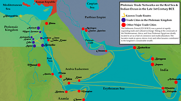
Ptolemaic Trade Networks in the Late 1st Century BCE
This map illustrates the trading networks which connected the Ptolemaic Kingdom to South Asia and East Africa by the second half of the 1st century BCE. During this time period, Ptolemaic Egypt was a major player in the spice trade which...

Image
Slave Trade
Execrable Human Traffick, or The Affectionate Slaves, oil on canvas by George Morland, c. 1788. Depicted here is a scene of a man being abducted by slavers on the coast of Africa as his family watches. From the 16th to the 19th century...

Definition
Mali Empire
The Mali Empire (1240-1645) of West Africa was founded by Sundiata Keita (r. 1230-1255) following his victory over the kingdom of Sosso (c. 1180-1235). Sundiata's centralised government, diplomacy and well-trained army permitted a massive...

Image
Map of the Trade Networks in the Middle Ages, c. 1200
By the early 13th century (c. 1200 CE), long-distance trade networks across Eurasia and the Mediterranean had regained a level of interconnectivity not seen since late antiquity. After the political fragmentation that followed the fall of...

Video
History of the Major Trade Routes - Summary on a Map
In this video, let's retrace the evolution of the world’s major trade routes, from the Incense Route until today.
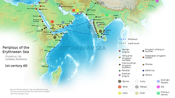
Image
Ancient Indian Maritime Trade Routes
This map is derived from the book Periplus of the Erythraean Sea. It depicts trade routes in the ancient world, ports in the Chera territory and other parts of India and the trade routes connecting them to other parts of the world along with...

Image
Transatlantic Triangular Trade Map
Map showing the flow of goods and enslaved people across the Atlantic between Europe, Africa and America in the transatlantic triangular trade which the European colonial powers operated from the 16th to the 19th centuries CE. This triangular...

Image
Map of Medieval Japanese Trade & Wako Pirates
Map depicting Medieval Japan and its trade relations with its neighbours, China and Korea. The map shows the major trade goods exchanged between Japan, China, and Korea. Black lines show the approximate routes taken by the Wako Pirates. Each...

Definition
Portuguese Brazil
With a wealth of natural resources, Brazil was by far the most important colony in the Portuguese empire and was, at one time or another, the world’s leading producer of sugar, diamonds, and tobacco. Colonised from the 1530s, most settlements...