
Search
Remove Ads
Advertisement
Search Results

Definition
Audiencia
An audiencia began as a judicial institution in medieval Spain, but in the 16th century, it was applied as the highest form of local government in key cities of the Spanish Empire. An audiencia had a panel of judges made responsible for the...
Interview
Interview: The Last Days of the Incas (Kim MacQuarrie)
How did a mere 167 Spaniards conquer an empire of 10 million people? The Spanish were outnumbered 200-to-1 yet they were able to seize the Inca capital, Cuzco, and dispose of the Inca ruler within only a year. Kim MacQuarrie's The Last Days...

Definition
Juan de Grijalva
Juan de Grijalva (aka Grijalba, 1489-1527) was a Spanish conquistador who explored the eastern coast of Mexico in 1518. His notable achievements included a demonstration that the Yucatán Peninsula was just that and not, as previously thought...

Image
Map of the British Conquest in India c. 1857
This map illustrates the rapid and often chaotic expansion of British control in India between the Battle of Plassey in 1757 and the eve of the Indian Rebellion in 1857. During this century, the East India Company transformed from a trading...

Image
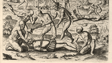
Spanish Torture of American Peoples
An illustration showing the torture of indigenous American peoples by Spanish conquistadors. From the 1552 edition of A Very Brief Recital of the Destruction of the Indies by Bartolomé de las Casas which was a graphic indictment of the exploitation...
Image
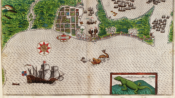
Cartagena on the Spanish Main
A c. 1589 map showing the port of Cartagena on the Spanish Main (now in modern Colombia). Cartagena was one of the main ports for the Spanish treasure fleets and acted as a collecting point for gold, silver, emeralds, and pearls from Colombia...

Image
Map of Roman Gaul from Conquest to Integration, c. 200 CE - Provincial Order and Frontier Power in the Roman West
The Roman incorporation of Gaul began with the campaigns of Julius Caesar (58–51 BCE) and resulted in the gradual transformation of a diverse Celtic region into an integral part of the Roman world. By c. 200 CE, Gaul was organized into a...
Image
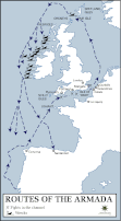
Route Map of the Spanish Armada
A map showing the route of the Spanish Armada from May to October 1588 CE. The Armada was sent by Philip II of Spain (r. 1556-1598 CE) to invade the kingdom of Elizabeth I of England (r. 1558-1603 CE) but was defeated by the Royal Navy and...

Image
The Spanish Armada of 1588 CE By van Wieringen
A 17th century CE painting by Cornelis Claesz van Wieringen of the Spanish Armada which sailed to invade England in 1588 CE. (Rijksmuseum, Amsterdam)
Image
Spanish Conquistadores Being Tortured
A 16th-century print by Theodor de Bry showing indigenous peoples gaining revenge on Spanish Conquistadores in the Americas by pouring molten gold down their throats. (From Grand Voyages Accounts to the Americas, and to Africa and the Orient...