
Search
Remove Ads
Advertisement
Search Results

Image
Vercingetorix
The colossal statue of Vercingetorix, near the village of Alise-Sainte-Reine, France. Napoleon III erected this seven-meter-tall statue of Vercingétorix in 1865 on the supposed site of Alesia.

Image
Caesar in Gaul
Artist's impression of how Caesar and his army marching through Gaul may have looked like. This is a marketing picture for the Rome II: Total War DLC "Caesar in Gaul".
Image
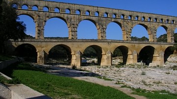
Pont Du Gard Aqueduct
The Pont Du Gard Roman aqueduct, Southern France, 1st century CE

Image
The Seven Sacks of Rome
An infographic of the seven times the city of Rome was sacked. Across more than 1,900 years (390 BCE–1527 CE), the sacks of Rome reveal not a single moment of collapse, but a recurring pattern of vulnerability shaped by shifting political...
Image
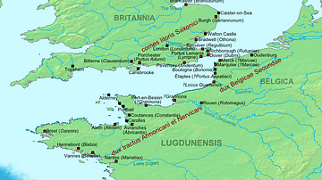
Map of the Saxon Shore, c. 380 CE
The Late Roman fortifications of the "Saxon Shore" (litus Saxonicum) in Britain and France.

Image
Celtic Warrior Figurine
A terracotta figurine of a Celtic warrior. Likely a Celtic Gaul. From Egypt, 220-180 BCE. (British Museum, London)

Image
Map of the Ptolemaic World
A map showing the known world at the time of the Ptolemaic Empire, ca. 300 BC.

Image
The Roman Aqueduct of Pont du Gard
The Pont du Gard is an aqueduct in the South of France constructed by the Roman Empire, and located in Vers-Pont-du-Gard near Remoulins, in the Gard département. It has long been thought that the Pont du Gard was built by Augustus' son-in-law...

Image
Siege of Alesia
This is an artistic 3D model of how the Battle of Alesia may have looked.
In this decisive Roman victory (September 52 BCE), Julius Caesar defeated the Arverni leader Vercingetorix, completing the Roman conquest of Gaul.

Image
The Dying Gaul
Marble copy of a lost ancient Greek statue known as The Dying Gaul, from ancient Rome (c. 230-220 BCE) commissioned by Attalos of Pergamon in honor of his victory over the Galatians.