
Search
Remove Ads
Advertisement
Search Results

Article
The Iberian Conquest of the Americas
European explorers began to probe the Western Hemisphere in the early 1500s, and they found to their utter amazement not only a huge landmass but also a world filled with several diverse and populous indigenous cultures. Among their most...

Article
Cousteau's Calypso - The World's Most Famous Research Ship
Slicing through tropical reefs or patrolling Arctic waters, the Calypso gained worldwide fame as the research ship of the French underwater explorer Jacques-Yves Cousteau. Seen by millions on TV documentaries broadcast worldwide, the Calypso...

Article
Travel in the Ancient Greek World
Travel opportunities within the ancient Greek world largely depended on status and profession; nevertheless, a significant proportion of the population could, and did, travel across the Mediterranean to sell their wares, skills, go on religious...

Article
In Search of the Promised Land: Saint Brendan’s Voyage
Between the 9th and the 10th century CE, in an unknown European abbey, an anonymous author told the story of an Irish monk and his 14 companions who embarked on a dangerous journey in the 5th century CE. The monk's name was Brendan, and his...

Article
Pilgrimage in the Byzantine Empire
Pilgrimage in the Byzantine Empire involved the Christian faithful travelling often huge distances to visit such holy sites as Jerusalem or to see in person relics of holy figures and miraculous icons on show from Thessaloniki to Antioch...

Video
How Magellan Circumnavigated the Globe - Ewandro Magalhaes
View full lesson: http://ed.ted.com/lessons/how-magellan-circumnavigated-the-globe-ewandro-magalhaes On September 6, 1522, the "Victoria" sailed into harbor in southern Spain. The battered vessel and its 18 sailors were all that remained...

Image
Map of the Spanish Colonial Empire
This map illustrates the rise and expansion of the Spanish Colonial Empire during the Age of Exploration, from the late 15th to the early 19th century. Emerging after the completion of the Reconquista in 1492 and the voyages of Christopher...
Image
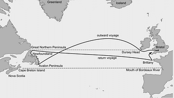
John Cabot's Route to Newfoundland
The Italian explorer John Cabot (aka Giovanni Caboto, c. 1450 - c. 1498 CE) sailed from England to eastern Canada in 1497 CE. His exact route and points of exploration are unclear and the map is therefore only an approximate guide.

Image
Voyage of Hanno the Carthaginian Explorer
A map indicating the possible route of Hanno, a Carthaginian who led a colonising and exploration expedition down the Atlantic coast of Africa in the 6th or 5th century BCE. Some scholars suggest he reached modern Sierra Leone, others that...
Image
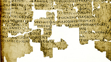
Aetia by Callimachus
A 2nd-century CE papyrus of Callimachus' Aetia.
B.P. Grenfell & A.S. Hunt, The Oxyrhynchus Papyri: Part XI. (London: The Egypt Exploration Society, 1915), plate IV