
Search
Remove Ads
Advertisement
Search Results
Image
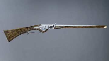
17th-Century Wheellock Carbine
A French 17th-century wheellock carbine. This type of weapon was typically used by cavalrymen, for example, during the English Civil Wars. (1642-51). This example is particularly ornate since it was possibly made for Louis XIII of France...

Image
Monte Cassino in the 15th Century
Illustration of Monte Cassino in the 15th-century Nuremberg Chronicle. Published in Nuremberg, Germany, 1493.

Image
Manticore at the Church of St Mary and St David, Kilpeck, Herefordshire (12th century)
Kilpeck church stone carvings: Manticore. Dating to the 12th century and found at the Church of St Mary and St David in Herefordshire, England.
Image
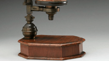
18th-Century Microscope
An early 18th-century microscope designed and made by John Marshall. It is a compound microscope, that is, it uses three lenses. Made of brass, wood, and other materials. (Science Museum, London)

Image
20th-Century Sepoy
An early-20th-century painting by Major A.C. Lovett of a sepoy in the British Indian Army. (From The Armies of India, 1911)
Image
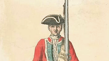
Mid-18th Century British Infantryman
An illustration of a mid-18th century British infantryman. 39th Regiment, 1742.
Image
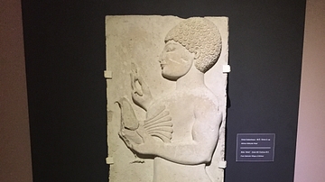
Lydian Relief: 5th Century BCE
This relief of a male holding a bird is from the 5th century BCE, found in modern day western Turkey near the ancient city of Thyatira. Thyatira was named such by Seleucos I Nicator around 290 BCE but prior to that it was an important city...

Image
Hydria (4th century BCE)
The hydria, as its name indicates, was used almost exclusively for carrying water (Greek hydor), essential for everyday cleansing, ritual purifications and libations. 4th-century BCE. Made from bronze. (Hellenic Museum, Melbourne, Victoria)

Image
Map of the First Three Crusades & the 12th-Century Outremer
These maps illustrate the trajectory of the early Crusades (1096–1192), a series of military campaigns launched by the medieval Latin Church with the declared goal of reclaiming the Holy Land—centered between the Mediterranean Sea and the...

Image
11th century CE Kievan Rus Territories
Map of Kievan Rus territories during the feudal split, after the death of Prince Yaroslav the Wise in 1054 CE.