
Search
Remove Ads
Advertisement
Search Results

Video
The Crisis of the Third Century Explained
The Crisis of the Third Century (also known as the Imperial Crisis, 235-284 CE) was the period in the history of the Roman Empire during which it splintered into three separate political entities: the Gallic Empire, the Roman Empire, and...

Video
Sultan Suleiman Marries Hurrem | Magnificent Century
Sultan Suleiman Marries Hurrem | Magnificent Century Click to watch full episode: https://www.youtube.com/watch?v=cooAiT3JY8k The golden years of the Ottoman Empire come to life in a television series. The life of Suleiman the Magnificent...

Video
The Roman Empire: Crisis of the 3rd Century - Full Documentary
The Crisis of the Third Century, also known as Military Anarchy or the Imperial Crisis (AD 235–284), was a period in which the Roman Empire nearly collapsed under the combined pressures of invasion, civil war, plague, and economic depression...

Image
Map of the Trade in the Indian Ocean 15th-16th century - From Afro-Asian Exchange to European Intervention
The Indian Ocean trade network of the 15th and 16th centuries formed one of the most extensive and dynamic systems of exchange in the premodern world, linking East Africa, the Middle East, South Asia, and Southeast Asia. This maritime system...

Image
Map of the Migration Period in Europe in the 4th-5th Century
The Migration Period in Europe (c. 4th–6th centuries CE) marks a prolonged era of movement, conflict, and political transformation rather than a single moment of collapse. Following the death of Emperor Theodosius I (reign 379–395 CE) and...

Image
Map of the Parthian Empire in the 2nd Century
This map illustrates the Parthian Kingdom (c. 247 BCE–224 CE), also known as the Arsacid Empire after its ruling dynasty. Emerging on the northeastern fringes of the Seleucid realm, the Parthians expanded their power as Seleucid control weakened...
Image
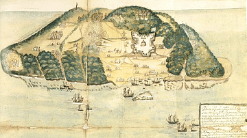
17th Century Tortuga
A 17th-century illustration of the buccaneer and pirate base of Tortuga, located on the northwest coast of Hispaniola (modern Haiti and the Dominican Republic).
Image
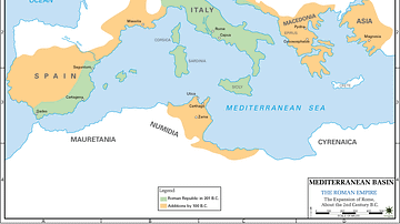
Map of 2nd Century Roman Expansion
A map showing the early expansions of Rome, in the 2nd century BC.
Image
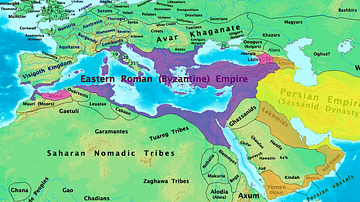
Byzantine & Persian Empires in the 7th Century
A map showing the extent of the Byzantine Empire and the Sasanian Empire in the 7th century.

Image
17th-century Depiction of Plague Doctor
A depiction of "Doctor Schnabel" ("Schnabel" is literally German for "Beak"), a plague doctor in Rome. The illustration appeared in a 17th -century German satirical manuscript. The engraving was first published by Paul Fürst (1608–1666...