
Search
Remove Ads
Advertisement
Search Results

Image
Map of Europe on the Eve of WWII, 1939
A map illustrating the growing instability in Europe in the lead-up to World War II, capturing the aggressive territorial expansion of Nazi Germany and the failure of appeasement. Between 1935 and 1939, a series of bold geopolitical moves...

Image
Map of the Dominant Religions in Europe, 16th Century - Shaping Nations Through Faith: The Religious Landscape of a Changing Continent
This map illustrates the major religious divisions across Europe during the 16th century, a period marked by the sweeping changes of the Reformation. As Protestant movements challenged the authority of the Catholic Church, the religious landscape...

Image
Map of Europe at the End of World War I, November 1918 - Lost Empires, Uncertain Borders, and New Nations
This map illustrates the geopolitical landscape of Europe in mid-November 1918, immediately after the signing of the Armistice of Compiègne (11 November 1918), which ended the First World War (1914–1918). The Great War, fought on an unprecedented...

Image
Map of the Spread of the Plague in Europe, 1346 - 1353
This map illustrates the spread of the 14th-century plague pandemic, the “Black Death,” which swept across Europe and the Middle East between 1346 and 1353. Originating in Central Asia, it traveled on merchant vessels carrying grain and furs...

Image
World War II in Europe, November 1942
A map depicting the strategic situation in Europe and the Mediterranean in early November 1942, as World War II reached a critical turning point. Axis expansion had begun to reverse, while the Allies launched major offensives in North Africa...

Image
Map of Europe on the Eve of World War I, Early 1914
Europe on the eve of World War I was defined by a volatile mix of alliance politics, imperial rivalry, and rising nationalism. The continent was divided into two heavily armed blocs, the Triple Alliance and the Triple Entente, binding the...

Image
Map of Europe after the War of the Austrian Succession, 1748 - Dynastic Rivalry and Balance of Power
The War of the Austrian Succession (1740–1748) reshaped the political balance of Europe after the death of Charles VI, Holy Roman Emperor (reign 1711–1740) and the contested accession of Maria Theresa (reign 1740–1780) to the Habsburg lands...

Image
The "Spring of Nations": Revolutionary Europe in 1848 - From Revolution to Reaction: Nationalism and Upheaval in Nineteenth-Century Europe
This map illustrates the sweeping republican revolts and political upheavals that erupted across Europe in 1848, a year known as the People's Spring or the Spring of Nations. Part of a broader continuum of revolutionary movements since the...
Image
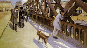
The Pont de l'Europe by Caillebotte
An 1876 oil on canvas, The Pont de l'Europe, by Gustave Caillebotte (1848-96) the French impressionist painter. Caillebotte uses the strong diagonal of the railway bridge to draw the viewer's eye down the street, following the dog. Such industrial...
Image
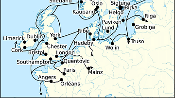
Viking Age Trade Routes in North-West Europe
Map showing some of the Viking Age (c. 790-1100 CE) trade routes that existed in North-West Europe during this time. Among the places depicted are such major trading centres are Hededy, Ribe, Birka and Kaupang from Viking Scandinavia; York...