
Browse Content

Image
Muslim Invasion of the Levant, 634 CE
A map depicting the Muslim invasion into the Levant, then controlled...

Image
Khalid ibn al-Walid's Campaign in Arabia
Map detailing the route of the conquest of central Arabia by Khalid...

Image
Rashidun Caliphate Under Caliph Abu Bakr
A map showing the Rashidun Caliphate (highlighted in green) by...

Image
North Africa After the Berber Revolt (739-743 CE)
Northwest Africa after 743 CE, when the Umayyad Caliphate had been...
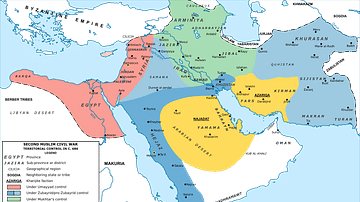
Image
Map of the Middle East during the Second Fitna (c. 686 CE)
A map depicting the divisions of the Islamic Empire during the...

Image
Fourth Crusader Invasion of Egypt, 1168-1169 CE
A map depicting the Fourth Crusader Invasion of Egypt from 1168...