
Browse Content
Image
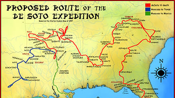
Route of the de Soto Expedition
Map showing the route of Hernando de Soto's expedition. Based on...

Image
Map of the Third Dynasty of Ur - Sumerian Temples, Tablets, and the Birth of Legal Tradition in Ancient Mesopotamia
This map illustrates the rise of the Sumerian city-state of Ur...

Image
Map of the Late Bronze Age Collapse c. 1200 - 1150 BCE
The Late Bronze Age Collapse (c. 1200–1150 BCE) marks a period...

Image
Map of Europe Before the Fall of Constantinople, c. 1450
Around 1450 CE, Europe and the Middle East were defined by fragmentation...

Image
Troop Dispositions, Battle of Dunbar in 1650
A map showing the troop dispositions of the Scottish and English...

Image
Map of Ptolemaic Egypt c. 240 BCE
This map illustrates the political landscape of Ptolemaic Egypt...