
Browse Content

Image
World Map of Herodotus
Possibly what the Greek historian Herodotus believed the world...

Image
Map of the Akkadian Empire
The empire of Sargon, late 24th century BCE.

Image
Map of the Greco-Bactrian Kingdom
Approximate maximum extent of the Greco-Bactrian kingdom circa...

Image
Map of Hannibal's Route into Italy
Hannibal's route into Italy in the Second Punic War.

Image
Map of Troy
Plan of the archeological site of Troy/Hisarlik. Legend: 1...
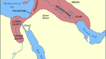
Image
Map of the Fertile Crescent
This map shows the location and extent of the Fertile Crescent...