


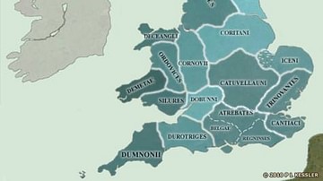
Map of Roman Britain ca. 150 AD, showing the main Roman roads, cities, and Brythonic tribes.
Related Images

Map of the British Isles in AD 43
Map of the British Isles in AD 10
Map of the British Isles in 54 BC

Map of Ancient Georgian States (600-150 BCE)

Map of the Roman Rule in Britain c. 43 - 410 CE - Four Centuries of Empire at the Edge of the World

Map of the Hadrian’s wall (Vallum Hadriani) c. 122 CE
Cite This Work
APA Style
nacu, A. (2012, April 26). Map of Roman Britain, 150 AD. World History Encyclopedia. https://www.worldhistory.org/image/575/map-of-roman-britain-150-ad/
Chicago Style
nacu, Andrei. "Map of Roman Britain, 150 AD." World History Encyclopedia, April 26, 2012. https://www.worldhistory.org/image/575/map-of-roman-britain-150-ad/.
MLA Style
nacu, Andrei. "Map of Roman Britain, 150 AD." World History Encyclopedia, 26 Apr 2012, https://www.worldhistory.org/image/575/map-of-roman-britain-150-ad/.