
Server Costs Fundraiser 2026


This historical map was produced to support the understanding of military operations conducted between the Lahn and Sieg rivers from 14 to 21 June 1796. It provides a geographic overview of the region during this critical phase of the campaign, serving as a valuable reference for analyzing troop movements and strategic positioning. Source: Votre Carte Ancienne – antique maps of Germany.
About the Author

Related Images
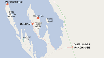
Map of Shark Bay Area Showing Dirk Hartog Island and Cape Inscription

Map of the Trade Links between Rome & the East

Battle of Guilford Court House, Battle Map

Map of Odysseus’ 10-year Journey Home
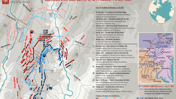
Map of Battle of Gettysburg during the American Civil War

Map of the Silk Road During the Late 8th Century
Cite This Work
APA Style
Denis, L. (2025, May 23). Map of the Area Between the Lahn and the Sieg: Military Operations, 14–21 June 1796. World History Encyclopedia. https://www.worldhistory.org/image/20473/map-of-the-area-between-the-lahn-and-the-sieg/
Chicago Style
Denis, Léopold. "Map of the Area Between the Lahn and the Sieg: Military Operations, 14–21 June 1796." World History Encyclopedia, May 23, 2025. https://www.worldhistory.org/image/20473/map-of-the-area-between-the-lahn-and-the-sieg/.
MLA Style
Denis, Léopold. "Map of the Area Between the Lahn and the Sieg: Military Operations, 14–21 June 1796." World History Encyclopedia, 23 May 2025, https://www.worldhistory.org/image/20473/map-of-the-area-between-the-lahn-and-the-sieg/.