


Map of the Siege of Hara Castle during the Shimabara Rebellion, c. 17th century. Note the Dutch ships at the top, who would have fired cannonades upon the defenders.
Related Images

Map of Mesopotamia, 2000-1600 BCE

Map of Elizabethan Trade with Europe, c. 1600 - Trade and Diplomacy in the Tudor World

Map of the The Mitanni (Hanigalbat) empire, c. 1600-1300 BCE - Between Egypt and the Hittites, A Kingdom of Diplomacy and War
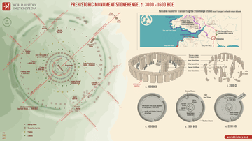
Prehistoric Monument Stonehenge, c. 3000-1600 BCE - Ceremonial Landscape on Salisbury Plain

Map of the Indian Rebellion (Sepoy Mutiny) of 1857

Map of the Siege of Toulon 18-19 Dec. 1793
Cite This Work
APA Style
Artist, U. (2023, July 21). Map of the Siege of Hara Castle, c. 1600. World History Encyclopedia. https://www.worldhistory.org/image/17610/map-of-the-siege-of-hara-castle-c-1600/
Chicago Style
Artist, Unknown. "Map of the Siege of Hara Castle, c. 1600." World History Encyclopedia, July 21, 2023. https://www.worldhistory.org/image/17610/map-of-the-siege-of-hara-castle-c-1600/.
MLA Style
Artist, Unknown. "Map of the Siege of Hara Castle, c. 1600." World History Encyclopedia, 21 Jul 2023, https://www.worldhistory.org/image/17610/map-of-the-siege-of-hara-castle-c-1600/.