


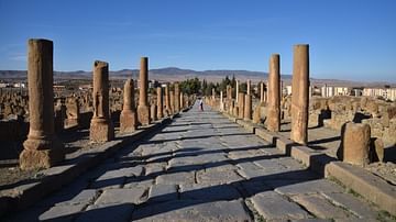
Like all Roman cities, Tipasa (modern Tipaza in Algeria) was organised around its two main axes: decumanus (main east-west street) and cardo (main south-north street). The Cardo Maximus, descending towards the sea, was paved and bordered by porticoes supported by rows of piers.
About the Author

License & Copyright
 This image was first published on Flickr. Original image by Carole Raddato. Uploaded by Carole Raddato, published on 31 January 2023. The copyright holder has published this content under the following license: Creative Commons Attribution-NonCommercial-ShareAlike. This license lets others remix, tweak, and build upon this content non-commercially, as long as they credit the author and license their new creations under the identical terms. When republishing on the web a hyperlink back to the original content source URL must be included. Please note that content linked from this page may have different licensing terms.
For commercial licensing enquiries, please contact our licensing agency Wright's Media.
Related Images
Cardo Maximus of Thamugadi (Timgad), Algeria

Cardo Maximus in Cuicul (Djémila)

Cardo Maximus, Caesarea Maritima

Reconstructed section of the Cardo Maximus of Aelia Capitolina (Jerusalem)

The Oval Forum and Cardo Maximus of Gerasa
Cardo Maximus of Carsulae, Italy
Cite This Work
APA Style
Raddato, C. (2023, January 31). Cardo Maximus in Tipasa. World History Encyclopedia. https://www.worldhistory.org/image/16962/cardo-maximus-in-tipasa/
Chicago Style
Raddato, Carole. "Cardo Maximus in Tipasa." World History Encyclopedia, January 31, 2023. https://www.worldhistory.org/image/16962/cardo-maximus-in-tipasa/.
MLA Style
Raddato, Carole. "Cardo Maximus in Tipasa." World History Encyclopedia, 31 Jan 2023, https://www.worldhistory.org/image/16962/cardo-maximus-in-tipasa/.