


A satellite image of the Straits of Magellan at the tip of South America. The Straits were first navigated by the Portuguese explorer Ferdinand Magellan (c. 1480-1521) whose expedition was the first to circumnavigate the globe in 1519-22.
Related Images
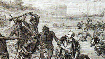
Death of Ferdinand Magellan
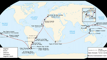
Map of Ferdinand Magellan's Circumnavigation

Portrait of Ferdinand Magellan

Ferdinand Magellan

Magellan's Ship Victoria

Archduke Franz Ferdinand Prior to His Assassination
Cite This Work
APA Style
NASA. (2021, June 14). The Straits of Magellan. World History Encyclopedia. https://www.worldhistory.org/image/14246/the-straits-of-magellan/
Chicago Style
NASA. "The Straits of Magellan." World History Encyclopedia, June 14, 2021. https://www.worldhistory.org/image/14246/the-straits-of-magellan/.
MLA Style
NASA. "The Straits of Magellan." World History Encyclopedia, 14 Jun 2021, https://www.worldhistory.org/image/14246/the-straits-of-magellan/.