


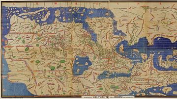
This detail shows a section of the Tabula Peutingeriana, a 13th Century map of the world believed to be based on a Roman original. This section of it includes Rome, the heart of the Roman Empire. The massive scroll measures 0.34 m (1 ft 1 in) x 6.75 m (22.1 ft), and is divided into eleven segments.
Related Images
Tabula Rogeriana

Mosaic Detail from the Roman Temple at Milreu, Portugal

Map of the Roman Empire under Theodosius the Great, c.395 - The Last Unified Roman Empire

Roman Sarcophagus (Detail)

The Roman Empire and the Crisis of the Third Century, c. 270 CE - Pretenders, Breakaways, Plague, and the Fight for Unity
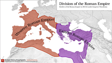
Western & Eastern Roman Empire, 395 CE
Cite This Work
APA Style
Miller, K. (2021, May 30). Detail of the Tabula Peutingeriana. World History Encyclopedia. https://www.worldhistory.org/image/14128/detail-of-the-tabula-peutingeriana/
Chicago Style
Miller, Konrad. "Detail of the Tabula Peutingeriana." World History Encyclopedia, May 30, 2021. https://www.worldhistory.org/image/14128/detail-of-the-tabula-peutingeriana/.
MLA Style
Miller, Konrad. "Detail of the Tabula Peutingeriana." World History Encyclopedia, 30 May 2021, https://www.worldhistory.org/image/14128/detail-of-the-tabula-peutingeriana/.