
Search
Remove Ads
Advertisement
Search Results

Image
The Three Graces, Louvre
Marble statue of the Three Graces dancing in a circle. 2nd century CE Roman copy of a Greek statue of the 2nd century BCE with Rennaisance era restorations. Found in the Villa Cornovaglia in Rome. Louvre Museum, Paris.

Image
Later Three Kingdoms Period
A map showing the political geography of Korea during the Later Three Kingdoms period (889-935 CE).
Image
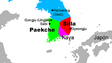
Three Kingdoms, Korea
A map showing the Three kingdoms of ancient Korea (57 BCE - 668 CE): Baekje (Paekche), Goguryeo (Koguryo), and Silla. There was also a fourth entity in this period, the Gaya (Kaya) Confederation.

Image
Three Graces Relief, Piraeus
A marble relief plaque showing the Three Graces. Copy of a c. 470 BCE original by Sokrates the Boetian sculptor. (Archaeological Museum, Piraeus)

Image
Maitreya Buddha, Three Kingdoms Period
A detail of a gilt bronze statue of the Maitreya (coming) Buddha. Three Kingdoms Period, Korea, c. 600 CE. Height: 80 cm. (National Museum of Korea, Seoul, South Korea)

Image
The Three Graces by Antonio Canova
The Three Graces, statue by Italian sculptor Antonio Canova, commissioned at the behest of Empress Joséphine de Beauharnais, c. 1813-1816.
Hermitage Museum, St. Petersburg.
Image
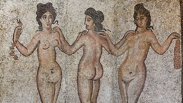
Mosaic of the Three Graces
Mosaic of the Three Graces from Caesarea in Mauretania (modern-day Cherchell in Algeria). Dated to the 4th century CE.
Archaeological Museum of Cherchell, Algeria.

Image
Relief with the Three Graces
Relief from the Sebasteion of Aphrodisias depicting the Three Graces in a typical Hellenistic style. The Sebasteion is a monumental complex dedicated to Aphrodite and the Julio-Claudian emperors in the 1st century CE. Aphrodisias Museum...

Definition
Ancient Korea
Korea, located on a large peninsula on the eastern coast of the Asian mainland, has been inhabited since Neolithic times. The first recognisable political state was Gojoseon in the second half of the first millennium BCE. From the 1st century...
Image
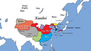
Three Kingdoms Period of China and the Rise of Xianbei in the year 229 CE
This map depicts the boundaries of all major civilizations in East Asia at the beginning of the Three Kingdoms Period of China, with italics indicating nomadic bands and other tribal societies. Following the collapse of Han Dynasty in 220...
