
Search
Remove Ads
Advertisement
Search Results

Article
Roman Expeditions in Sub-Saharan Africa
Sub-Saharan Africa was explored by Roman expeditions between 19 BCE - 90 CE, most likely in an effort to locate the sources of valuable trade goods and establish routes to bring them to the seaports on the coast...

Definition
Treaty of Tordesillas
The 1494 Treaty of Tordesillas (Tordesilhas) was an agreement between the monarchs of Spain and Portugal to divide the world between them into two spheres of influence. The imaginary dividing line ran down the centre of the...

Video
How did Polynesian Wayfinders Navigate the Pacific Ocean
Learn more about TED-Ed Clubs here: https://ed.ted.com/clubs Visit the TED-Ed Clubs YouTube channel: https://www.youtube.com/channel/UCskU_g7t6b5ecsA1CTS3y9Q View full lesson: https://ed.ted.com/lessons/how-did-polynesian-wayfinders-navigate-the-pacific-ocean-alan-tamayose-and-shantell-de-silva...

Article
Naval Warfare in Ancient India
The navy in ancient India carried out three roles: it was used to transport troops to distant battlefields, participate in actual warfare, and was primarily meant for protecting the kingdom's trade on sea and navigable...

Definition
Portuguese Angola
Portuguese Angola in southwest Africa was the first European colony on that continent. While settlement from 1571 proved problematic in the interior, the Portuguese did obtain a large number of slaves which they shipped to their...
Image
Ancient Indian Ship
This relief depicts an ancient Indian ship likely to have been used by Indian adventurers sailing to Java, Indonesia.
Location: Borobudur temple, Magelang, Central Java, Indonesia

Image
Map of the Trade Networks in the Middle Ages, c. 1200
By the early 13th century (c. 1200 CE), long-distance trade networks across Eurasia and the Mediterranean had regained a level of interconnectivity not seen since late antiquity. After the political...

Definition
Portuguese Nagasaki
Nagasaki, on the northwest coast of Japan’s Kyushu Island, was an important Portuguese trading base from c. 1571 to 1639, and the most eastern outpost of the Portuguese empire. The Portuguese presence transformed Nagasaki from...

Article
Trail of Tears: Memorial and Protest of the Cherokee Nation by John Ross
The Trail of Tears was the forced relocation of the "Five Civilized Tribes" – Cherokee, Chickasaw, Choctaw, Muscogee Creek, and Seminole – from their ancestral lands in the Southeastern...
Image
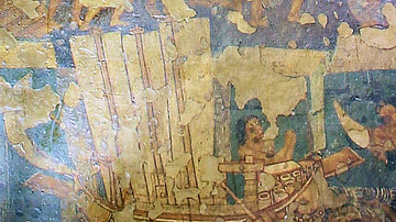
Ancient Indian Ship
This Ajanta mural depicts an ancient Indian ship with high stem and stern and three oblong sails attached to three masts. Steering-oars can also be seen. Location: Cave No. 2, Ajanta Caves, Aurangabad District, Maharashtra...
