
Search
Did you mean: Easter?
Remove Ads
Advertisement
Search Results
Image
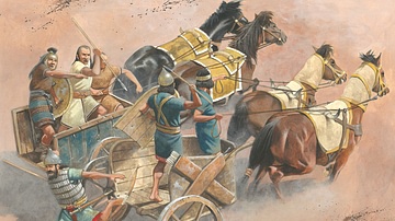
Chariot Warfare in the Ancient Near East
An illustration of what chariot warfare looked like in the ancient Near East. Illustration by by Zvonimir Grbasic.

Image
East Pagoda, Yakushiji
The East Pagoda of Yakushiji temple, Nara, Japan. The three-story pagoda is original and dates to the 8th century CE and rises to a height of 33 metres (108 ft).

Image
Weavers, Scribes, and Kings: A New History of the Ancient Near East by Amanda H. Podany
Weavers, Scribes, and Kings: A New History of the Ancient Near East by Amanda H. Podany

Image
Parthenon, East Facade
East facade of the Parthenon, Athens, 5th century BCE.

Image
The Near East in 1135 CE
This map of the Near East in 1135 CE shows four Crusader States (marked with red crosses) in relation to other powerful kingdoms in the period between the first and second crusades.

Image
East Pediment of the Parthenon
The left section of the east pediment of the Parthenon. On the far left Helios and his chariot rise from the base of the pediment, next is Dionysos reclining, then the figures are female deities, possibly Demeter, Kore and Artemis. (British...

Image
Athena (after the East pediment of the Parthenon)
A Pentelic marble statue of Athena considered to be similar to that originally on the East pediment of the Parthenon. The statue was dedicated to Artemis, mid-3rd century CE. (National Archaeological Museum, Athens)

Image
Map of East Asia
A map of East Asia showing China, Korea and Japan.

Image
East Roman Empire, 6th century CE
East Roman Empire, 6th century CE, showing the territories of the Avars, Goths, Franks, Lombards, Saxons, Thuringians, Slavs.

Image
Map of East Frisia
Map of East Frisia by the Dutch Johannes Florianus (1522-1585) for the Theatrum Orbis Terrarum, one of the first accurate modern atlas, 1595.