
Search
Remove Ads
Advertisement
Search Results

Definition
War of 1812
The War of 1812 (1812-1815), referred to by some contemporaries as the Second American Revolution, was fought between the United States and the United Kingdom. Often remembered only as a sideshow to the Napoleonic Wars, the war had...

Image
Map of the Greek City-states c. 500 BCE
This map illustrates the city-states of Classical Greece around 500 BCE, highlighting the rise of the polis system and the growing reach of Hellenic influence along the Mediterranean and Black Sea coasts. The...

Article
Battle of Midway - Japan's First Naval Defeat in WWII
The Battle of Midway, 4-6 June 1942, was the turning point of the Pacific War. The US Pacific fleet sank four Japanese aircraft carriers for the loss of only one US carrier, the Yorktown, and destroyed...

Definition
Amistad Seizure - The Court Case that Captivated the World
The Amistad Seizure (also known as the Amistad Incident, the Amistad Rebellion, the Amistad Mutiny, and Amistad Revolt) was a conflict aboard the Spanish schooner La Amistad in July 1839, off the...
Image
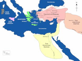
Map of the Hittite Empire and Surrounding States
A map of the Hittite Empire and surrounding states, including the Assyrian Empire, the Egyptian Empire, and Ahhiyawa. This map is an extract from the book Empires of Bronze by Gordon Doherty, republished...
Image
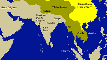
Tang Empire & Neighbouring States
A map indicating the extent of the Tang empire (618-907 CE) and its neighbouring states and tribes people.
Image
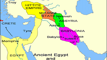
States of the Fertile Crescent, c. 1450 BCE
A map illustrating the various political states within the Fertile Crescent c. 1450 BCE.

Image
Kushan Empire & Neighboring States
This map shows the extent of the Kushan empire along with the various states and kingdoms that surrounded it at roughly the same time period. c. 100 - 240 CE.

Image
Map of Ancient Georgian States (600-150 BCE)
Map showing the ancient states in the western Caucasus (modern-day Georgia) from c. 600 BCE to 150 BCE.

Image
Map of the Crusader States, 1229-1240 CE
A map indicating the territories controlled by the Crusader States or Latin East from 1229 CE to 1240 CE after the Sixth Crusade (1227-1229 CE)
