
Search
Search Results
Image
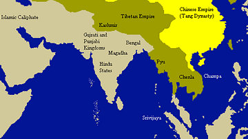
Tang Empire & Neighbouring States
A map indicating the extent of the Tang empire (618-907 CE) and its neighbouring states and tribes people.

Image
Kushan Empire & Neighboring States
This map shows the extent of the Kushan empire along with the various states and kingdoms that surrounded it at roughly the same time period. c. 100 - 240 CE.

Image
Map of the Crusader States, 1229-1240 CE
A map indicating the territories controlled by the Crusader States or Latin East from 1229 CE to 1240 CE after the Sixth Crusade (1227-1229 CE)

Image
Map of Ancient Georgian States (600-150 BCE)
Map showing the ancient states in the western Caucasus (modern-day Georgia) from c. 600 BCE to 150 BCE.

Image
Map of Korean States in 108 BCE
A map of the Korean states in 108 BCE.
Image
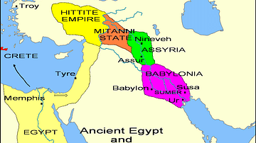
States of the Fertile Crescent, c. 1450 BCE
A map illustrating the various political states within the Fertile Crescent c. 1450 BCE.

Definition
Kellogg-Briand Pact - When 63 States Signed Up for Peace
The Kellogg-Briand Pact was an agreement signed in August 1928 by 63 countries, which all promised, after the horrors of the First World War (1914-18), to regard war as an illegal instrument of national policy. Unfortunately, this sentiment...

Image
Baltic States 1100-1400 CE
This map illustrates the Baltic states in the period 1100-1400 CE.

Image
Crusader States 1200 CE
This map shows the crusader states c. 1200 CE.
Image
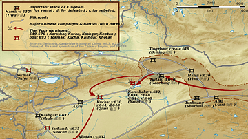
Taizong's Campaigns Against the Xiyu States
A map illustrating the campaigns of Tang Dynasty emperor Taizong (r. 626-649 CE) against the Xiyu states in China.