
Search
Remove Ads
Advertisement
Search Results

Image
Roman Emperor Philip the Arab
Marble head of Roman Emperor Philip the Arab, from Rome, 244-249 CE. (Ny Carlsberg Glyptotek, Copenhagen)

Definition
Gertrude Bell
Gertrude Bell (l. 1868-1926) was an archaeologist, travel writer, explorer, and political administrator responsible for creating the borders of the countries of the Near East after World War I and, especially, for the foundation of the modern...

Image
Arab Room Tiles, Sintra Palace
Islamic ceramic tiles in the Arab Room in the Sintra palace (Palácio Nacional de Sintra), Portugal. King Manuel I of Portugal (r.1495-1521 CE) imported azulejos (glazed ceramic tiles) from the Alhambra palace in Granada, Spain to decorate...

Image
Votive Head Mace of La-arab, King of Gutium
This partially mutilated head mace was inscribed with an Akkadian cuneiform script, which mentions that this stone head mace is a votive offering dedicated by La-arab, king of Gutium. Although they left little evidence of their rule, it appears...
Image
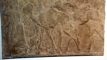
Captured Camels from Arab Enemies of Tiglath-pileser III
The woman on the left and the herd of camels behind her are part of a procession of prisoners and booty captured during one of the military campaigns of Tiglath-pileser III (reigned 744-727 BCE) against Arab enemies. Assyrian, about 728 BCE...
Image
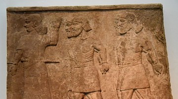
Review of Arab Prisoners, Assyrian Relief
Assyrian relief, from the Central Palace at Nimrud (ancient Kalhu), Mesopotamia, Iraq, Neo-Assyrian Empire, c. 728 BCE. This is part of a series of reliefs showing Arab prisoners brought before the Assyrian King Tiglath-Pileser III (r. 744-727...

Article
US Involvement in WWI - From Isolationism to Military Intervention
The United States remained neutral in the first three years of the First World War (1914-18) but did finally join the conflict at the end of 1917 following the threat of unrestricted submarine warfare on US merchant shipping and a secret...

Image
Captured Flocks from Arab Enemies of Tiglath-pileser III
Sheep and goats, captured in a campaign against the Arabs are driven back to the Assyrian camp. This scene decorated the palace of King Tiglath-pileser III (reigned 744-727 BCE. Assyrian, about 728 BCE. From the Central Palace at Nimrud (ancient...

Image
The United States Constitution, 1787
The United States Constitution (1787) represents the foundational legal and political framework of the American republic, drafted to replace the ineffective Articles of Confederation (1781) and unify the newly independent states under a stronger...

Image
Map of the United States, 1874
A map of the United States, showing each of its states, published by D.G. Beers & Co. in 1874.
From the Lionel Pincus and Princess Firyal Map Division, The New York Public Library.