
Search
Remove Ads
Advertisement
Search Results

Image
Map of the African Slave Trade, c. 1750
By c. 1750, Africa stood at the center of three major slave-trading systems, the transatlantic, trans-Saharan, and Indian Ocean trades, each connecting African societies to wider global economies. These networks operated simultaneously but...
Image
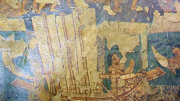
Ancient Indian Ship
This Ajanta mural depicts an ancient Indian ship with high stem and stern and three oblong sails attached to three masts. Steering-oars can also be seen.
Location: Cave No. 2, Ajanta Caves, Aurangabad District, Maharashtra state, India

Image
Map of the Trade Networks of the Ancient Mediterranean World - Connectivity & Expansion in the Archaic and Classical Ages
Between the 7th and 4th centuries BCE, the Mediterranean functioned as a highly interconnected zone of maritime exchange, shaped by the expanding networks of Phoenician and Hellenic communities. Originating from the Levant, Phoenician traders...
Definition
Mystic Massacre of 1637
The Mystic Massacre of 1637 (also known as the Pequot Massacre) was the pivotal event of the Pequot War (1636-1638) in New England fought between the English (along with their Native American allies the Mohegan and Narragansett tribes) and...

Image
Map of the Indian Rebellion (Sepoy Mutiny) of 1857
The Indian Rebellion of 1857 was a transformative uprising that shook British rule in South Asia. Sparked in May 1857 by mutinous sepoys ((from Persian sepāhī, for soldier)) of the East India Company in Meerut, Uttar Pradesh, the revolt quickly...

Article
Battle of Hydaspes
For almost a decade, Alexander the Great and his army swept across Western Asia and into Egypt, defeating King Darius III and the Persians at the battles of River Granicus, Issus and Gaugamela. Next, despite the objections of the loyal army...

Image
Map of the Hanseatic League Trade Network, c. 1400
The Hanseatic League (c. 13th–17th centuries) was a powerful network of merchant guilds and cities that dominated trade across northern Europe for centuries. Emerging in the late Middle Ages, the League united towns from Lübeck, Hamburg...

Definition
John Hawkins
Sir John Hawkins (1532-1595 CE) was an Elizabethan mariner, merchant and naval administrator who has the inglorious (if not wholly accurate) record of being England's first slave trader. In the 1560s CE Hawkins trafficked slaves from West...

Article
Pirate Havens in the Golden Age of Piracy
The buccaneers who roamed the Spanish Main and the pirates who plundered the Caribbean and the Indian Ocean during the Golden Age of Piracy (1690-1730) needed a place of refuge where they could share out and enjoy their loot. Pirate havens...

Image
North America in the French and Indian War 1754–1763 - A Colonial War and the Roots of American Revolution
This map illustrates the course and key developments of the French and Indian War (1754–1763), the North American theater of the global Seven Years' War between Great Britain and France. It shows the territorial struggles, shifting alliances...