
Search
Remove Ads
Advertisement
Search Results

Definition
XYZ Affair
The XYZ Affair was a diplomatic incident that occurred in 1797-98, involving diplomats from the United States and Revolutionary France. Amidst rising tensions between the two nations, President John Adams sent envoys to Paris to negotiate...

Definition
Napoleon Bonaparte
Napoleon Bonaparte (1769-1821) was a Corsican-born French general and politician who reigned as Emperor of the French with the regnal name Napoleon I from 1804 to 1814 and then again briefly in 1815. He established the largest continental...
Definition
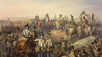
Battle of Neerwinden
The Battle of Neerwinden saw the major defeat of a French republican army by an allied force of Austrians and Dutch during the War of the First Coalition (1792-97), part of the broader French Revolutionary Wars (1792-1802). The battle drove...

Definition
Napoleon's Campaign in Egypt and Syria
The French Expedition to Egypt and Syria (1798-1801), led by Napoleon Bonaparte, aimed to establish a French colony in Egypt and to threaten British possessions in India. Despite initial French victories, the campaign ultimately ended in...

Definition
Battle of Valmy
The Battle of Valmy was a stunning French victory over a Prussian-led coalition army on 20 September 1792, during the French Revolutionary Wars (1792-1802). Although the battle was little more than a skirmish, it halted the coalition's invasion...

Article
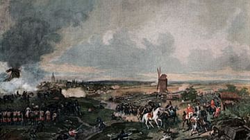
Battle of Tourcoing
The Battle of Tourcoing (17-18 May 1794) was a major engagement in the War of the First Coalition, the first phase of the French Revolutionary Wars (1792-1802). It saw an army of the French Republic successfully fend off a six-pronged attack...

Article
Ten Notorious French Pirates
Piracy has involved many nationalities over the centuries, but one of the prominent groups in the medieval and early modern periods was the French pirates, who terrorised the Atlantic, the Caribbean, and the Indian Ocean. French writers often...

Article
4 Women of the French Revolution
The French Revolution (1789-1799) sought to dismantle the oppressive society of the old regime and build a new world based on the principles of "Liberty, Equality, Fraternity". This push for societal change led to a burgeoning feminist movement...

Article
Battle of Wattignies
The Battle of Wattignies was a significant battle in the War of the First Coalition, part of the wider French Revolutionary Wars (1792-1802). It was fought on 15-16 October 1793 between a ragtag army of the First French Republic and a professional...
Article
Battle of Hondschoote
The Battle of Hondschoote, fought on 6-8 September 1793, was a major turning point in the Flanders Campaign of 1792-1795 during the French Revolutionary Wars (1792-1802). An army of the First French Republic defeated an Anglo-Hanoverian force...