
Search
Remove Ads
Advertisement
Search Results

Definition
Lend-Lease - The WWII US Aid Programme for Allies
Lend-Lease (sometimes called Lease-Lend) was a programme of financial and material aid given by the United States to its allies during the Second World War (1939-45). Food, weapons, ammunition, and agricultural equipment were amongst the...

Image
Map of the Greek City-states c. 500 BCE
This map illustrates the city-states of Classical Greece around 500 BCE, highlighting the rise of the polis system and the growing reach of Hellenic influence along the Mediterranean and Black Sea coasts. The period saw Athens and Sparta...

Video
The Hanoverian Queens & Consorts of The United Kingdom 7/8
The German Hanoverian Queens of Great Britain and later the United Kingdom had some of the most epic royal matrimonial brawls in history. One brought enlightenment thinking to court. One was dear friends with Marie Antoinette and endured...

Definition
Gilbert du Motier, Marquis de Lafayette
Marie-Joseph Paul Yves Roch Gilbert du Motier, Marquis de La Fayette (l. 1757-1834), more commonly known in the United States as simply Lafayette, was a French aristocrat, military officer, and politician. He was a major figure in both the...

Article
Ancient Christianity’s Effect on Society & Gender Roles
Christianity began as a sect of Judaism in Judea in the 1st century CE and spread to the cities of the Eastern Roman Empire and beyond. In these cities, non-Jews, Gentiles, wanted to join the movement, and these Gentile-Christians soon outnumbered...
Image
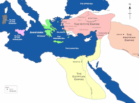
Map of the Hittite Empire and Surrounding States
A map of the Hittite Empire and surrounding states, including the Assyrian Empire, the Egyptian Empire, and Ahhiyawa.
This map is an extract from the book Empires of Bronze by Gordon Doherty, republished with permission.

Image
Map of the Crusader States, 1229-1240 CE
A map indicating the territories controlled by the Crusader States or Latin East from 1229 CE to 1240 CE after the Sixth Crusade (1227-1229 CE)

Image
Kushan Empire & Neighboring States
This map shows the extent of the Kushan empire along with the various states and kingdoms that surrounded it at roughly the same time period. c. 100 - 240 CE.
Image
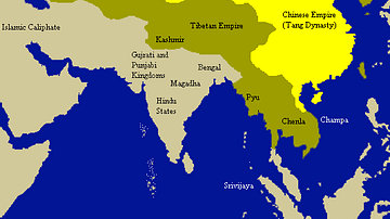
Tang Empire & Neighbouring States
A map indicating the extent of the Tang empire (618-907 CE) and its neighbouring states and tribes people.

Image
Map of Ancient Georgian States (600-150 BCE)
Map showing the ancient states in the western Caucasus (modern-day Georgia) from c. 600 BCE to 150 BCE.