
Search
Remove Ads
Advertisement
Search Results
Definition
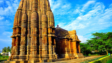
Bhubaneshwar
Bhubaneshwar (also spelt Bhubaneswar, Bhubanesar, and Bhuvanesvar) is a city located in the Orissa district of north-eastern India and flourished as a centre of Hindu worship from the 7th century CE. Its mass of well-preserved sandstone...

Article
The Crusades: Causes & Goals
The Crusades were a series of military campaigns organised by Christian powers in order to retake Jerusalem and the Holy Land back from Muslim control. There would be eight officially sanctioned crusades between 1095...

Image
The Byzantine Empire in the mid-9th century CE
A map of the Byzantine Empire, c. 867 CE.

Image
Anglo-Saxon Clothing, 6-9th century CE
An illustration of the typical clothing worn by Anglo-Saxons in medieval England, c. 500 - c. 1000 CE. ('Costumes of all Nations', 1882 CE)

Video
Fall of The Roman Empire...in the 15th Century: Crash Course World History #12
Crash Course World History is now available on DVD! Visit http://dft.ba/-CCWHDVD to buy a set for your home or classroom. You can directly support Crash Course at http://www.subbable.com/crashcourse...

Image
The Korean Peninsula and the Japanese Archipelago, 3rd-6th century CE
Map of Pen/Insular states and potential centres in the 3rd–6th centuries CE.

Image
Map of Japan in the 16th Century CE
A map of Japan during the Azuchi-Momoyama period (1568-1600 CE).

Image
Crispus Attucks Portrait from the 19th Century
An image of Crispus Attucks created c. 1854 when he became an inspirational figure for the abolitionist movement in the United States. There is no way of knowing whether this image represents the actual...

Image
Map of Celtic Expansion - 6th-3rd century BCE
A map showing the various campagins of Celtic tribes between the 6th and 3rd centuries BCE.

Image
15-century CE Nautical Map
Nautical chart of the North-East Atlantic Ocean, the Baltic Sea, the Mediterranean Sea and the Black Sea, accompanied by a circular world map. Alleged author: Cristopher Columbus (l. 1451-1506 CE) Gallica Digital Library...
