
Browse Content
Image
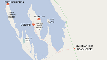
Map of Shark Bay Area Showing Dirk Hartog Island and Cape Inscription
Dutch explorer, Dirk Hartog (1580-1621), sailed into Shark Bay...
Image
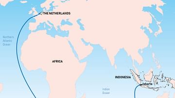
The Brouwer Route
The Dutch East India Company's favoured route from Europe to southeast...

Image
Chart of the Malay Archipelago and the Dutch Discoveries in Australia
Chart of the Malay Archipelago and the Dutch discoveries in Australia...

Image
Willem Janszoon's Expedition 1605-1606
Map of the route of Willem Janszoon's (c. 1570-c. 1630) expedition...

Image
Map of the Neo-Assyrian Empire
The Neo-Assyrian Empire emerged out of a renewed phase of Assyrian...

Image
Map of the Middle Assyrian Empire
The Middle Assyrian Empire emerged amid the dynamic political realignments...