
Browse Content

Image
Map of the Quest of Jason and the Argonauts
This map follows the legendary voyage of Jason and the Argonauts...

Image
Map of Christian Pilgrimage in the Middle Ages, c. 1000
This map illustrates the changing patterns of Christian pilgrimage...

Image
Viceroyalty of New Spain, c. 1800
This map illustrates the Viceroyalty of New Spain, the earliest...
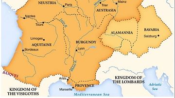
Image
Merovingian Kingdoms
Map of the Merovingian kingdoms at their height.

Image
Map of East Frisia
Map of East Frisia by the Dutch Johannes Florianus (1522-1585...

Image
Map of the Early Christian Pilgrimage (4th-5th Century)
The rise of Christian pilgrimage begins after the conversion of...