
Browse Content

Image
Map of the British Raj c. 1930
A map illustrating the British Raj around 1930, a period of direct...

Image
Map of the Indian Rebellion (Sepoy Mutiny) of 1857
The Indian Rebellion of 1857 was a transformative uprising that...
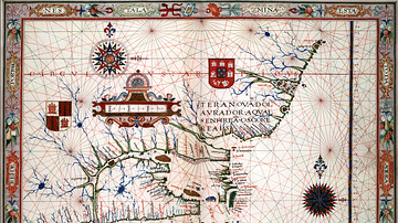
Image
Map of Newfoundland, 1570
Map of Newfoundland and Labrador made by the Portuguese cartographer...

Image
Mughal India c. 1707
A map illustrating the emergence and expansion of one of the largest...

Image
Map of the British Conquest in India c. 1857
This map illustrates the rapid and often chaotic expansion of British...

Image
Robert Clive & The East India Company Rule in India, c. 1765
A map illustrating the transformation of the East India Company...