
Search Images
Browse Content (p. 95)

Image
Martin Van Buren
Martin Van Buren (1782-1862) photographed during his retirement, circa 1860.
Brady-Handy photograph collection, Library of Congress, Washington, D.C.

Image
Van Buren as President
US President Martin Van Buren, oil on canvas by Henry Inman, circa 1837.
Metropolitan Museum of Art, New York.

Image
Whig Political Cartoon About the Panic of 1837
A Whig political cartoon showing the effects of the Panic of 1837. By Henry Dacre, 1838.
Library of Congress, Washington, D.C.

Image
Martin Van Buren, 1849
Former President Martin Van Buren, daguerrotype by Mathew Brady, around 1849-50.
Yale University Library.
Image
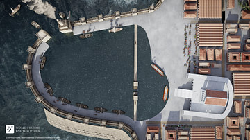
Unique Structures at Herod's Harbor
As part of Herod the Great's building program, besides the unattached edifices at the entrance to Herod's Harbor, there is material evidence for two other unique structures. One was a low-lying breakwater south of the harbor’s tower-and-wall...

Image
Hindenburg Lounge Area
A full-size replica of the lounge area of the Hindenburg, a German Zeppelin airship, which was in service from 1936 to 1937.
Zeppelin Museum Friedrichshafen.

Image
LZ 129 Hindenburg over New York
The German Zeppelin airship LZ 129 Hindenburg flying over New York, c. 1936.

Image
British Airship R 34
A photograph of the British airship R 34 landing at Long Island, New York on 6 July 1919 having crossed the Atlantic Ocean, the first airship to do so. (Library of Congress)

Image
John C. Calhoun, 1823
John C. Calhoun, Secretary of War, oil on canvas by Charles Bird King, c. 1823.
National Portrait Gallery, Smithsonian Institution, Washington, D.C.

Image
Hindenburg Zeppelin Tethered
The LZ 129 Hindenburg, a German Zeppelin airship, which carried passengers between Europe and the Americas. The Hindenburg measured a massive 804 feet (245 m) in length with a maximum internal frame diameter of 135 feet (41.2 m). The airship...