
Search Images
Browse Content (p. 1840)

Image
The Braschi Antinous
The colossal statue of Antinous, favourite of Roman Emperor Hadrian, who drowned in the Nile in 130 CE and was officially made a god by the emperor. Excavated from the site of Hadrian's villa. (The Vatican Museums, Rome).

Image
Roman Ivory Doll
A Roman ivory doll from the mid-2nd century CE. From the 'Grottarossa Mummy' sarchophagus, Rome. (Palazzo Massimo, Rome)
Image
Eros
Eros the Greek god of love and desire from an Attic red-figure kylix, 510-500 BCE. (Museo Archeologico Etrusco, Florence).
Image
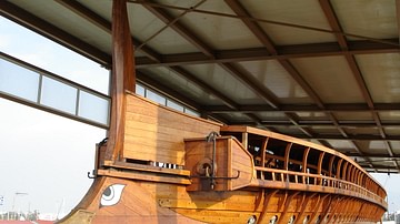
Trireme Hull with Bronze Ram
The hull of the Olympias, a full-scale reconstruction of an ancient Greek trireme warship. The principal strategy in battle of the trireme was to sink or damage the oars of an enemy vessel using the bronze ram fixed to the ship's prow. Triremes...
Image
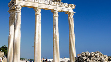
Temple of Apollo, Side
The remains of the 2nd century CE Temple of Apollo at Side (modern-day Turkey).

Image
Battle of Salamis, 480 BCE
The distribution of the respective fleets of the Greek allied states (blue) against the Persian forces of Xerxes (red), 480 BCE. The Greeks would outmanoeuvre the Persians in the shallow waters of the straights and win a victory which would...

Image
Roman Statue of Anubis
A Roman marble statue of the Egyptian god Anubis. Provenance: Anzio, Villa Pamphili, 1st-2nd century CE. (Vatican Museums, Rome).
Image
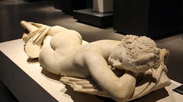
Sleeping Hermaphrodite
A Roman marble sculpture of a sleeping hermaphrodite displaying both male and female anatomy. A mid-2nd century CE copy of mid-2nd century BCE bronze original from Asia Minor. (Palazzo Massimo, Rome).
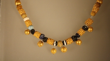
Image
Roman Necklace
A Roman necklace in gold and glass paste, 6-5 BCE. From a sarcophagus at Fidene, Rome. (Palazzo Massimo, Rome).

Image
Roman Sarcophagus (Detail)
A detail from a Roman sarcophagus in Procennesian marble depicting the Calydonian boar hunt from Greek mythology. The Greek hero Meleager attacks the boar with his spear while Artemis looks on. Provenance: Vicovaro, date unknown. (Capitoline...