
Search Images
Browse Content (p. 1801)
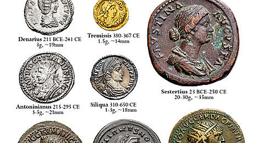
Image
Roman Coins
Some of the most common Roman coins, including the gold aureus, silver denarius and brass sestertius.

Image
Siddhartha Gautama, the Historical Buddha
The Buddha seated in meditation, one hand on his lap, the other pendant in a gesture known as earth-witness, which represents unshakability or steadfastness when being subject to the demons' temptations. This is a superb example of 12th century...

Image
Jesus Christ Pantokrator
The oldest known icon depicting Jesus Christ (6th century) in Saint Catherine's Monastery, Egypt.

Image
Cambyses II of Persia
Cambyses II of Persia after winning the battle of Pelusium on 525 BC, capturing Psamtik III of Egypt and conquering Egypt. Please accept this.

Image
Temple of Castor & Pollux
The three remaining Corinthian columns of the Temple of Castor & Pollux in the Roman Forum, Rome. The present temple dates from the end of the 1st century BCE and early 1st century CE but replaced a temple also dedicated to the demi-god twins...
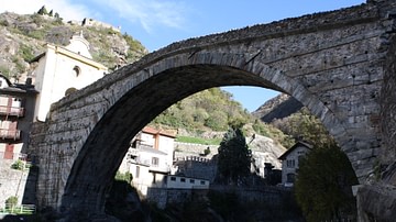
Image
Roman Bridge, Pont-Saint-Martin
The Roman bridge of Pont-Saint-Martin in northern Italy, built between 142 and 22 BCE along the Gallic consular road. The bridge, at its highest point, is 46.25 m above the river Lys and the arch spans 31.55 m.
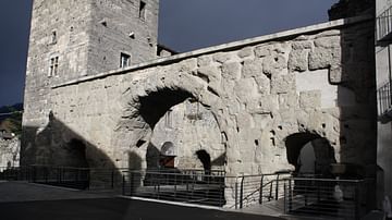
Image
Praetorian Gate, Aosta
The interior gate of the 25 BCE double Praetorian Gate of Aosta in northern Italy. The two gates stand 12 m apart and each has three arched entrances - one central gateway for wheeled vehicles and two smaller passages positioned either side...
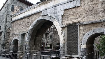
Image
Porta Praetoria, Aosta
One of the gates of the 25 BCE double Praetorian Gate of Aosta in northern Italy. The two gates stand 12 m apart and each has three arched entrances - one central gateway for wheeled vehicles and two smaller passages positioned either side...

Image
Roman Theatre Façade, Aosta
The 22 m high façade (scaena) of the Roman theatre at Aosta in northern Italy. The theatre was constructed in the 1st century CE and further extended in the 3rd century CE. The theatre had a capacity of 3-4,000 spectators.

Image
Arch of Augustus, Aosta
The Triumphal Arch known as the Arch of Augustus in Aosta, northern Italy. The arch was erected in the reign of Augustus in 25 BCE to honour the emperor and his victory over the Salssi. The central iron crucifix and roof are more modern additions...