
Search Images
Browse Content (p. 1061)

Image
Kublai Khan Naming Phakpa Imperial Preceptor
Kublai (Qubilai) Khan Naming Phakpa Imperial Preceptor, c. 1270 CE; attributed to Khyentse Chenmo (flourished 1450s–1490s CE); Tibet; late 15th–16th century CE; pigments on cloth; 32 1/4 x 20 in. (82.6 x 50.8 cm); Art Gallery of Greater Victoria...

Image
Initiation of Kublai Khan
Initiation of Kublai (Qubilai) Khan and Offering Tibet to Phakpa in 1264 CE; Tibet; c. 16th–17th century; pigments on cloth; 24 1/4 x 15 1/8 in. (61.5 x 38.4 cm); Rubin Museum of Art; C2002.3.2 (HAR 65046)
Image
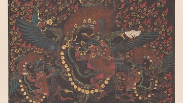
Raven-Headed Mahakala
Raven-Headed Mahakala; Bhutan; early to mid-19th century CE; pigments on cloth; 27 7/8 x 20 in. (70.8 x 50.8 cm); Rubin Museum of Art; C2006.42.8 (HAR 89189)
Image
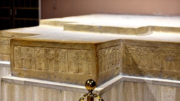
Throne Dais of Shlamaneser III at the Iraq Museum
This dais was found in the eastern end of the throne room (T1) at Fort Shalmaneser in the city of Nimrud (in modern-day Nineveh Governorate, Iraq) in 1962 CE. The upper surface is decorated with geometrical floral motifs and inscribed with...

Image
Two Statues of Shalmaneser III at the Iraq Museum
In the centre of this image is the so-called Kurba'il statue of Shalmaneser III (reigned 858-824 BCE), which was found in Fort Shalmaneser in 1961 CE by the British School of Archaeology in Iraq. The statue originally stood in the Temple...
Image
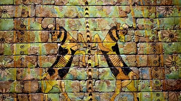
Glazed Wall Panel from Fort Shalmaneser
Detail of a large wall panel of vibrant glazed bricks once placed above the entrance to a vast room (T3) next to Shalmaneser III's throne room. The whole panel is composed of about 300 bricks and is 4 meters in length; this detail at the...

Image
Lamassu from Khorsabad at the Iraq Museum
This is one of a pair of colossal lamassus from the Palace of Sargon II at Khorsabad (in modern-day Nineveh Governorate, Iraq). Both of them are on display at the Assyrian Gallery of the Iraq Museum in Baghdad. During the ransacking of the...
Image
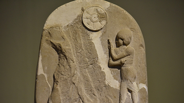
Stele of Dadusha at the Iraq Museum (detail)
This detail shows the upper register of the stele of Dadusha. The stele is an elongated stone monument which originally stood at the Temple of Adad at Eshnunna. The front side is carved with four registers while the narrow sides were inscribed...

Image
Assyrian Eunuch from Khorsabad at the Iraq Museum
This image shows a detail of an almost-3-meter high alabaster bas-relief from the Palace of the Assyrian king Sargon II at Khorsabad (in modern-day Nineveh Governorate, Iraq). This is an Assyrian eunuch, holding a cup; its bottom is in the...
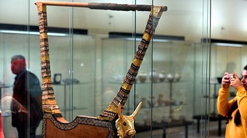
Image
The Golden Lyre of Ur at the Iraq Museum
This is the finest among all lyres found at the Royal Cemetry at Ur and was given to the Iraq Museum; the other lyres were divided between the British Museum in the UK and the Penn Museum in the USA. The head of this bull is a replica and...