
Search Images
Browse Content (p. 100)

Image
Battle of Churubusco
Battle of Churubusco (20 Aug 1847), fought during the campaign to capture Mexico City during the Mexican-American War (1846-1848). By John Cameron, published by Nathan Currier, 1847.
Library of Congress, Washington, D.C.

Image
Taylor at the Battle of Palo Alto
Gen. Zachary Taylor leads the American troops at the Battle of Palo Alto (8 May 1846). By an artist with the initials C.S., published by N. Currier, 1846.
Library of Congress, Washington, D.C.

Image
James K. Polk, 1849
US President James K. Polk (1795-1849) at the end of his term, February 1849. Reproduction of a daguerrotype by Mathew Brady.
Library of Congress, Washington, D.C.

Image
Surrender of Santa Anna after San Jacinto
Mexican General Antonio López de Santa Anna surrenders to Sam Houston's Texian force after the Battle of San Jacinto (21 April 1836), securing Texas' independence. Painting by William Henry Huddle, 1886; in the Texas State Capitol, Austin...

Image
Antonio López de Santa Anna
Antonio López de Santa Anna, oil on canvas by Manuel Paris, mid-19th century.
Museo Nacional de Historia Castillo de Chapultepec

Image
The Fall of the Alamo
The Fall of the Alamo or Crockett's Last Stand by Robert Jenkins Onderdonk, 1903.
Governor's Mansion of Austin, TX.

Image
Battle of Buena Vista
Battle of Buena Vista (23 Feb 1847) between US and Mexican armies during the Mexican-American War (1846-1848). Hand-colored lithograph by Adolphe Jean-Baptiste Bayot, after a drawing by Carl Nebel, 1851.

Image
Battle of Río San Gabriel
Battle of Río San Gabriel (8 Jan 1847) between US forces and the Californios during the Mexican-American War (1846-1848), oil on canvas by James Walker, circa 19th century.

Image
Towers and Arches at Herod's Harbor
As part of Herod the Great's building program, about Herod's Harbor in Caesarea Maritima, Josephus mentions “a great number of arches where the mariners dwelt” and “very large towers on a wall that ran around it.” The breakwater arms to which...
Image
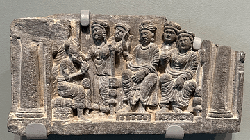
Queen Maya's Dream Is Explained
Queen Maya’s dream is explained, stone relief from the Gandhara region, modern-day Pakistan, circa 100-300 CE.
Asian Art Museum, San Francisco.