
Search Images
Browse Content (p. 100)
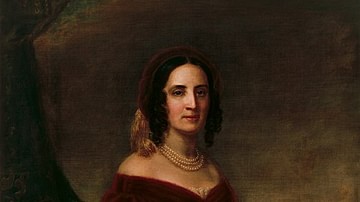
Image
Sarah Childress Polk
Portrait of First Lady Sarah Childress Polk (1803-1891), wife of US Pres. James K. Polk, oil on canvas by George Dury, 1883, after an original painting by George Peter Alexander Healy, 1846.
White House, Washington, D.C.

Image
Polk's Presidential Portrait
Official presidential portrait of James K. Polk (served 1845-1849). Oil on canvas by George Peter Alexander Healy, 1858.
White House, Washington, D.C.
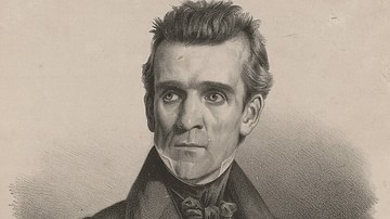
Image
James Polk as Speaker of the House of Representatives
James K. Polk (1795-1849) as Speaker of the US House of Representatives (1835-1839). Artwork by Charles Fendrich, printed by Peter S. Duval, 1838.
Library of Congress, Washington, D.C.
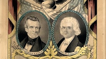
Image
Democrat Campaign Banner for the 1844 Election
A campaign banner for the Democratic Party candidates of the US Presidential Election of 1844: James K. Polk (left) and his running mate George M. Dallas (right). Lithograph with watercolor by Nathaniel Currier, 1844. Library of Congress...

Image
General Scott Enters Mexico City
US General Winfield Scott occupies Mexico City on 14 September 1847 at the end of the Mexican-American War (1846-1848). By Carl Nebel, 1851.
New York Public Library.

Image
Battle of Molina del Rey
Battle of Molina del Rey (8 Sept 1847) in the Mexican-American War (1846-1848). Hand-colored lithograph by Adolphe Jean-Baptiste Bayot, after a drawing by Carl Nebel, 1851.

Image
Battle of Churubusco
Battle of Churubusco (20 Aug 1847), fought during the campaign to capture Mexico City during the Mexican-American War (1846-1848). By John Cameron, published by Nathan Currier, 1847.
Library of Congress, Washington, D.C.

Image
Taylor at the Battle of Palo Alto
Gen. Zachary Taylor leads the American troops at the Battle of Palo Alto (8 May 1846). By an artist with the initials C.S., published by N. Currier, 1846.
Library of Congress, Washington, D.C.

Image
James K. Polk, 1849
US President James K. Polk (1795-1849) at the end of his term, February 1849. Reproduction of a daguerrotype by Mathew Brady.
Library of Congress, Washington, D.C.

Image
Surrender of Santa Anna after San Jacinto
Mexican General Antonio López de Santa Anna surrenders to Sam Houston's Texian force after the Battle of San Jacinto (21 April 1836), securing Texas' independence. Painting by William Henry Huddle, 1886; in the Texas State Capitol, Austin...