
Search Images
Browse Content (p. 10)

Image
Athena and Penelope
Athena by Penelope's side as she weaves, by Philipp Veit, Germany, c. 1811-1877. The goddess Athena plays a crucial role in Homer's Odyssey. One way in which she serves as a divine helper is by supporting Penelope, Odysseus's wife, in her...

Image
Penelope Stares at Her Shroud
Leuckart Certificate (Penelope stares at her Shroud), by Max Klinger, Germany, c. 1900. A print of Penelope, Odysseus's unflinching wife in Homer's Odyssey, as she stares at the shroud she has been weaving for years. The shroud acts as a...

Image
Map of the New Kingdom Egypt under Ramesses II - Egypt, Nubia, Hittites, and the Late Bronze Age c. 1250 BCE
The New Kingdom of Egypt (c. 1570–1069 BCE) marked the height of ancient Egypt’s political power, territorial expansion, and imperial ambition. Emerging after the expulsion of the Hyksos and the reunification of Egypt under Ahmose I (r.eign...

Image
Vespucci and the Map That Named America - Waldseemüller’s 1507 Map and the Invention of the New World
The naming of America was not the result of a single voyage or discovery, but of a chain of Atlantic expeditions, printed letters, and Renaissance mapmaking. Christopher Columbus (1451–1506) reached the Caribbean in 1492 while seeking a westward...
Image
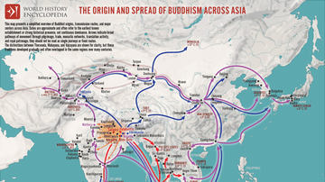
Map of the Spread of Buddhism Across Asia - The Making of a Pan-Asian Religion
Buddhism originated in the Ganges Plain of Magadha (modern Bihar, India) during the 5th–4th centuries BCE, following the enlightenment of Siddhartha Gautama, the Buddha (c. 5th century BCE). Initially transmitted through oral teaching and...

Image
Maginot Line, 1940
An August 1940 photograph of a portion of the Maginot Line after being taken by German troops. The defensive system was built along France's eastern frontiers prior to the Second World War (1939-45) but was largely bi-passed by Germany's...

Image
Soldier Accommodation, Maginot Line
A photograph of an accomodation room of the Maginot Line, the defensive system built along France's eastern frontiers prior to the Second World War (1939-45). From the Schoenenbourg fort, Bas-Rhin, France.

Image
Maginot Line Tunnel System
A photograph of part of the tunnel network of the Maginot Line, the defensive system built along France's eastern frontiers prior to the Second World War (1939-45). From the Schoenenbourg fort, Bas-Rhin, France.

Image
Retractible Turret, Maginot Line
An example of a mixed gun retracting turret of the Maginot Line, the defensive system built along France's eastern frontiers prior to the Second World War (1939-45). Alsace region.

Image
Signing the UN Charter
A photograph showing the signing of the United Nations Charter on 26 June 1945 at the San Francisco Conference.