


A map showing the political divisions in ancient Egypt during the Third intermediate Period, about 730 BC. The rulers of the 22nd and 23rd Dynasties ruled simultaneously, alongside Libyan chieftains controlling most of the Delta.
Related Images

Map of the Third Dynasty of Ur - Sumerian Temples, Tablets, and the Birth of Legal Tradition in Ancient Mesopotamia
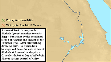
Third Crusader Invasion of Egypt, 1166-1167 CE
Egypt in the Early Hyksos Period

The Roman Empire and the Crisis of the Third Century, c. 270 CE - Pretenders, Breakaways, Plague, and the Fight for Unity

Map of the ancient Near East during the Amarna Period
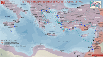
Paul the Apostle's Third Missionary Journey (c. 53-57 CE)
Cite This Work
APA Style
Dahl, J. (2012, April 26). Map of the Third Intermediate Period. World History Encyclopedia. https://www.worldhistory.org/image/596/map-of-the-third-intermediate-period/
Chicago Style
Dahl, Jeff. "Map of the Third Intermediate Period." World History Encyclopedia, April 26, 2012. https://www.worldhistory.org/image/596/map-of-the-third-intermediate-period/.
MLA Style
Dahl, Jeff. "Map of the Third Intermediate Period." World History Encyclopedia, 26 Apr 2012, https://www.worldhistory.org/image/596/map-of-the-third-intermediate-period/.