


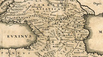
Map showing the ancient states in the western Caucasus (modern-day Georgia) from c. 600 BCE to 150 BCE.
-en.svg)
Related Images

Map of the Caucasus after the Peace of Nisibis, c. 300 CE
Map of Colchis

Map of India, 600 BCE

The Median Empire and the Ancient Near East, c. 600 BCE

Map of the Greek City-states c. 500 BCE

Spread of Christianity Map (up to 600 CE)
Cite This Work
APA Style
Deu. (2014, March 31). Map of Ancient Georgian States (600-150 BCE). World History Encyclopedia. https://www.worldhistory.org/image/2475/map-of-ancient-georgian-states-600-150-bce/
Chicago Style
Deu. "Map of Ancient Georgian States (600-150 BCE)." World History Encyclopedia, March 31, 2014. https://www.worldhistory.org/image/2475/map-of-ancient-georgian-states-600-150-bce/.
MLA Style
Deu. "Map of Ancient Georgian States (600-150 BCE)." World History Encyclopedia, 31 Mar 2014, https://www.worldhistory.org/image/2475/map-of-ancient-georgian-states-600-150-bce/.